| Strethall | |
|---|---|
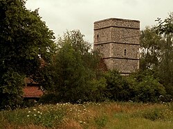 St. Mary's church, Strethall. | |
Strethall Location within Essex | |
| Population | 27 (Parish, 2021)1 |
| OS grid reference | TL482393 |
| • London | 39.5 mi (63.6 km) |
| Civil parish |
|
| District | |
| Shire county | |
| Region | |
| Country | England |
| Sovereign state | United Kingdom |
| Post town | SAFFRON WALDEN |
| Postcode district | CB11 |
| Police | Essex |
| Fire | Essex |
| Ambulance | East of England |
| UK Parliament | |
| Website | Strethall homepage |
Strethall is a village and civil parish in the Uttlesford district, in the county of Essex, England, near the town of Saffron Walden. At the 2021 census the parish had a population of 27.
Having suffered no casualties in World War I it is known as one of the thankful villages.2
The Icknield Way Path passes through the village on its 110-mile route between Ivinghoe Beacon in Buckinghamshire and Knettishall Heath in Suffolk. The 3 A route for walkers, horse riders and off-road cyclists also passes through the village.
References
References
- "2021 Census Parish Profiles". NOMIS. Office for National Statistics. Retrieved 31 March 2025. (To get individual parish data, use the query function on table PP002.)
- "Thankful Villages – A project about rural life by Darren Hayman". thankful-villages.co.uk. Retrieved 9 June 2026.
- Icknield Way Trail