Stormsrivier | |
|---|---|
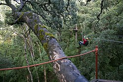 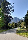 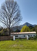  Clockwise from Top: Canopy Tours, Assegai Street, De Oude Pastorie building, the Tsitsikamma Mountains seen from Stormsrivier | |
Stormsrivier Stormsrivier | |
| Coordinates: 33°58′00″S 23°53′00″E / 33.966667°S 23.883333°E / -33.966667; 23.883333 | |
| Country | South Africa |
| Province | Eastern Cape |
| District | Sarah Baartman |
| Municipality | Kou-Kamma |
| Area | |
• Total | 1.82 km2 (0.70 sq mi) |
| Population (2011)1 | |
• Total | 1,670 |
| • Density | 918/km2 (2,380/sq mi) |
| Racial makeup (2011) | |
| • Black African | 43.0% |
| • Coloured | 48.8% |
| • Indian/Asian | 0.1% |
| • White | 7.5% |
| • Other | 0.5% |
| First languages (2011) | |
| • Afrikaans | 58.7% |
| • Xhosa | 32.2% |
| • English | 6.4% |
| • Other | 2.8% |
| Time zone | UTC+2 (SAST) |
| PO box | 6308 |
| Area code | 042 |
Stormsrivier is a settlement in Sarah Baartman District Municipality in the Eastern Cape province of South Africa.
The village lies just off the N2 road. The majority of the residents live in RDP housing on the outskirts of the village.2
References
References
- "Main Place Stormsrivier". Census 2011.
- "Storms River (Stormsrivier), Eastern Cape". SA Travel Directory. Retrieved 4 January 2014.