Stecklenberg | |
|---|---|
 Coat of arms | |
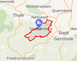 Location of Stecklenberg | |
Stecklenberg Stecklenberg | |
| Coordinates: 51°44′N 11°5′E / 51.733°N 11.083°E / 51.733; 11.083 | |
| Country | Germany |
| State | Saxony-Anhalt |
| District | Harz |
| Town | Thale |
| Area | |
• Total | 5.98 km2 (2.31 sq mi) |
| Elevation | 265 m (869 ft) |
| Population (2006-12-31) | |
• Total | 663 |
| • Density | 111/km2 (287/sq mi) |
| Time zone | UTC+01:00 (CET) |
| • Summer (DST) | UTC+02:00 (CEST) |
| Postal codes | 06507 |
| Dialling codes | 03947 |
| Vehicle registration | HZ |
Stecklenberg (German pronunciation: [ˈʃtɛklənbɛʁk]) is a village and a former municipality in the district of Harz, in Saxony-Anhalt, Germany. Since 23 November 2009, it is part of the town Thale.
Sights
The Glockenstein is a granite block in the shape of a bell that was probably used in prehistoric times as an Old Germanic cult site. Today it is checkpoint 73 on the Harzer Wandernadel hiking network.1
References
References
- Stempelstelle 73 / Glockenstein at www.harzer-wandernadel.de. Retrieved 1 Nov 2017.