| Skidegate Inlet | |
|---|---|
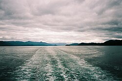 View of Skidegate Inlet from the east | |
Skidegate Inlet Location in British Columbia | |
| Location | Haida Gwaii, British Columbia, Canada |
| Coordinates | 53°14′N 132°02′W / 53.233°N 132.033°W / 53.233; -132.033 |
| Type | Inlet |
Ocean/sea sources | Pacific Ocean |
| Settlements | Daajing Giids, Skidegate |
Skidegate Inlet is a broad inlet on the east coast of the Haida Gwaii archipelago of the North Coast of British Columbia, Canada.1 It is the easternmost of a series of waterways separating Graham Island to the north from Moresby Island to the south.
Name origin
The name is derived from that of the village, which gets its name from one of the hereditary chiefs there, Chief Skidegate, whose chiefly name means "red paint stone".1
Geography
Skidegate Inlet is a located between Graham Island to the north, Skidegate Channel to the southwest, Hecate Strait to the east, and Moresby Island to the south.
The village of Daajing Giids (previously named Queen Charlotte)2 and community of Skidegate are located on its northern shore on Graham Island.
References
References
- "Skidegate Inlet". BC Geographical Names. Government of British Columbia – B.C. Geographical Names Office (BCGNO). Retrieved April 21, 2014.
- Ministry of Municipal Affairs (July 13, 2022). "Ancestral Haida name restored to Haida Gwaii village". BC Gov News. Government of British Columbia. Retrieved July 23, 2022.