| Shkhara | |
|---|---|
| შხარა Ушхара | |
 | |
| Highest point | |
| Elevation | 5,203 m (17,070 ft)12 |
| Prominence | 1,357 m (4,452 ft)3 |
| Listing | |
| Coordinates | 43°00′02″N 43°06′44″E / 43.00056°N 43.11222°E / 43.00056; 43.11222 |
| Geography | |
Shkhara Location of Shkhara within the Caucasus mountains Show map of Caucasus MountainsShkhara Shkhara (Kabardino-Balkaria) Show map of Kabardino-BalkariaShkhara Shkhara (Samegrelo-Zemo Svaneti) Show map of Samegrelo-Zemo Svaneti | |
| Location | Svaneti, Georgia Kabardino-Balkaria, Russia |
| Parent range | Main Caucasian Range Greater Caucasus Mountains |
| Climbing | |
| First ascent | 1888 by U. Almer, J. Cockin and C. Roth4 |
| Easiest route | Northeast Ridge: snow/ice climb (Russian grade 4b)54 |
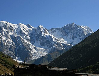
Shkhara (Georgian: შხარა; Karachay-Balkar: Ушхара, romanized: Uşxara; Russian: Шхара) is a mountain peak and the highest point in Georgia.67 It is located on the Georgia–Russia border, in Russia's Kabardino-Balkaria region on the northern side, and the Svaneti region of Georgia in the south. Shkhara is the highest peak of the Greater Caucasus Mountain Range since both Elbrus and Dykhtau are located along the side ranges, which lie to the north of it. Shkhara lies 88 kilometres (55 mi) north of Kutaisi, Georgia's second-largest city, and right at the townlet of Mestia. The summit lies in the central part of the Greater Caucasus Mountain Range, south-east of Mount Elbrus, Europe's highest mountain. Shkhara is the third-highest peak in the Caucasus, just behind Dykh-Tau.8
Morphology
Shkhara is the high point and the eastern anchor of a massif known as the Bezengi Wall, a 11–12-kilometre-long (6.8–7.5 mi) ridge. It is a large, steep peak in a heavily glaciated region, and presents serious challenges to mountaineers. Its north face (on the Russian side) is 1,500 metres (4,900 ft) high and contains several classic difficult routes. The significant sub-summit Shkhara West, at 5,068 m (16,627 ft), is a climbing objective in its own right, and a traverse of the entire Bezingi Wall is considered "Europe's longest, most arduous, and most committing expedition".4
History
The peak was first climbed in 1888 via the North East Ridge route, by the British/Swiss team of English climber John Garforth Cockin and Swiss guides Ulrich Almer and Christian Roth.9
References
References
- Bolashvili, Nana; Neidze, Vazha, eds. (2022). The Physical Geography of Georgia. Springer. p. 25. ISBN 978-3-030-90752-5.
- Tielidze, Levan, ed. (2019). Geomorphology of Georgia. Springer. p. 121. ISBN 978-3-319-77763-4.
- https://worldribus.org/caucasus-mountains/
- Audrey Salkeld, ed. (1998). World Mountaineering. Bulfinch Press. p. 70. ISBN 0-8212-2502-2.
- Shkhara on Summitpost
- "Shkhara - Peakbagger.com". www.peakbagger.com. Retrieved 2019-04-13.
- Encyclopaedia Britannica Almanac 2010. Encyclopaedia Britannica, Inc. 1 January 2010. ISBN 978-1-61535-329-3.
- Shkhara. Weather Forecast, Georgia mountain-forecast.com
- J. G. Cockin, « Shkara, Janga, and Ushba », The Alpine Journal, vol. XVI, n° 122, novembre 1893, pp. 477-494 - reproduced in Douglas W. Freshfield, The exploration of Caucasus, E. Arnold, 1896, Volume II, pp. 38-58