Serralunga d'Alba | |
|---|---|
| Comune di Serralunga d'Alba | |
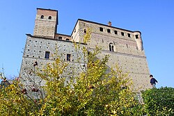 The castle | |
 Coat of arms | |
Serralunga d'Alba Location of Serralunga d'Alba in Italy Show map of ItalySerralunga d'Alba Serralunga d'Alba (Piedmont) Show map of Piedmont | |
| Coordinates: 44°36′39″N 8°0′0″E / 44.61083°N 8.00000°E / 44.61083; 8.00000 | |
| Country | Italy |
| Region | Piedmont |
| Province | Cuneo (CN) |
| Government | |
| • Mayor | Sergio Moscone |
| Area | |
• Total | 8.44 km2 (3.26 sq mi) |
| Elevation | 414 m (1,358 ft) |
| Population (31 December 2010)2 | |
• Total | 535 |
| • Density | 63.4/km2 (164/sq mi) |
| Demonym | Serralunghesi |
| Time zone | UTC+1 (CET) |
| • Summer (DST) | UTC+2 (CEST) |
| Postal code | 12050 |
| Dialing code | 0173 |
| Patron saint | St. Sebastian |
| Saint day | January 20 |
| Website | Official website |
Serralunga d'Alba is a comune (municipality) in the Province of Cuneo in the Italian region Piedmont, located about 60 kilometres (37 mi) southeast of Turin and about 45 kilometres (28 mi) northeast of Cuneo. It was built in the 14th century.

Serralunga d'Alba borders the following municipalities: Alba, Castiglione Falletto, Diano d'Alba, Monforte d'Alba, Montelupo Albese, Roddino, and Sinio. Main sights include Serralunga d'Alba Castle.
References
References
- "Superficie di Comuni Province e Regioni italiane al 9 ottobre 2011". Italian National Institute of Statistics. Retrieved 16 March 2019.
- All demographics and other statistics: Italian statistical institute Istat.