| Sandom Branch Tributary to Blackbird Creek | |
|---|---|
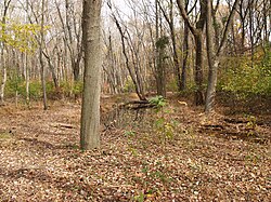 Floodplain of Sandom Branch downstream of DE 1 in 2008 | |
Location of Sandom Branch mouth Show map of DelawareSandom Branch (the United States) Show map of the United States | |
| Location | |
| Country | United States |
| State | Delaware |
| County | New Castle |
| Physical characteristics | |
| Source | divide between Sandom Branch and Duck Creek |
| • location | about 2 miles south of Blackbird, Delaware2 |
| • coordinates | 39°20′37″N 075°40′22″W / 39.34361°N 75.67278°W / 39.34361; -75.672781 |
| • elevation | 50 ft (15 m)2 |
| Mouth | Blackbird Creek |
• location | Blackbird, Delaware2 |
• coordinates | 39°22′27″N 075°39′10″W / 39.37417°N 75.65278°W / 39.37417; -75.652781 |
• elevation | 0 ft (0 m)2 |
| Length | 2.33 mi (3.75 km)3 |
Basin size | 2.78 square miles (7.2 km2)3 |
| Discharge | |
| • location | Blackbird Creek |
| • average | 3.28 cu ft/s (0.093 m3/s) at mouth with Blackbird Creek3 |
| Basin features | |
| Progression | Blackbird Creek → Delaware Bay → Atlantic Ocean |
| River system | Blackbird Creek |
| Tributaries | |
| • left | unnamed tributaries |
| • right | unnamed tributaries |
Sandom Branch is a 2.33 mi (3.75 km) long tributary to Blackbird Creek in New Castle County, Delaware. Sandom Branch is one of the major tributaries to Blackbird Creek above tidal influence.
Course
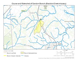
Sandom Branch rises on the Duck Creek divide about 2 miles south of Blackbird, Delaware.2
Watershed
Sandom Branch drains 2.78 square miles (7.2 km2) of area, receives about 43.8 in/year of precipitation, has a topographic wetness index of 556.57 and is about 22.6% forested.3
Maps
References
References
- "GNIS Detail - Sandom Branch". geonames.usgs.gov. US Geological Survey. Retrieved 31 July 2019.
- "Sandom Branch Topo Map, New Castle County DE (Clayton Area)". TopoZone. Locality, LLC. Retrieved 31 July 2019.
- "Sandom Branch Watershed Report". Waters Geoviewer. US EPA. Retrieved 31 July 2019.