Sandbumoen | |
|---|---|
Village | |
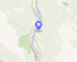 Interactive map of Sandbumoen | |
Sandbumoen Location within Innlandet Show map of InnlandetSandbumoen Location within Norway Show map of Norway | |
| Coordinates: 61°43′41″N 9°33′00″E / 61.72803°N 9.55006°E / 61.72803; 9.55006 | |
| Country | Norway |
| Region | Eastern Norway |
| County | Innlandet |
| District | Gudbrandsdalen |
| Municipality | Sel Municipality |
| Area | |
• Total | 0.24 km2 (0.093 sq mi) |
| Elevation | 332 m (1,089 ft) |
| Population (2024)1 | |
• Total | 241 |
| • Density | 1,004/km2 (2,600/sq mi) |
| Time zone | UTC+01:00 (CET) |
| • Summer (DST) | UTC+02:00 (CEST) |
| Post Code | 2670 Otta |
Sandbumoen3 is a village in Sel Municipality in Innlandet county, Norway. The village is located along the Gudbrandsdalslågen river, about 5 kilometres (3.1 mi) south of the town of Otta and about the same distance north of the village of Sjoa. The European route E6 highway and the Dovrebanen railway line both pass through the village.4
The 0.24-square-kilometre (59-acre) village has a population (2024) of 241 and a population density of 1,004 inhabitants per square kilometre (2,600/sq mi).1

References
References
- Statistisk sentralbyrå (1 October 2024). "Urban settlements. Population and area, by municipality".
- "Sandbumoen, Sel". yr.no. Retrieved 5 June 2022.
- "Informasjon om stadnamn". Norgeskart (in Norwegian). Kartverket. Retrieved 10 August 2025.
- Mæhlum, Lars, ed. (1 August 2025). "Sandbumoen". Store norske leksikon (in Norwegian). Foreningen Store norske leksikon. Retrieved 10 August 2025.