Saaleplatte | |
|---|---|
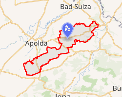 Location of Saaleplatte | |
Saaleplatte Saaleplatte | |
| Coordinates: 51°1′48″N 11°36′1″E / 51.03000°N 11.60028°E / 51.03000; 11.60028 | |
| Country | Germany |
| State | Thuringia |
| District | Weimarer Land |
| Disbanded | 2019 |
| Subdivisions | 9 |
| Area | |
• Total | 42.83 km2 (16.54 sq mi) |
| Elevation | 265 m (869 ft) |
| Population (2006-12-31) | |
• Total | 3,147 |
| • Density | 73.48/km2 (190.3/sq mi) |
| Time zone | UTC+01:00 (CET) |
| • Summer (DST) | UTC+02:00 (CEST) |
| Postal codes | 99510 |
| Vehicle registration | AP |
| Website | www.saaleplatte.info |
Saaleplatte (German pronunciation: [ˈzaːləˌplatə], lit. 'Saale Plateau') is a former municipality in the Weimarer Land district of Thuringia, Germany. On 31 December 2019, it was merged into the town Bad Sulza.1