Article · Wikipedia archive · Last revised Aug 5, 2026

Rugged Rocks

Rugged Rocks is a small group of rocks at the west side of the south entrance to McFarlane Strait, lying just north of Renier Point, Burgas Peninsula on Livingston Island, in the South Shetland Islands. These rocks were known to early sealers in the area and appear on Powell's map of 1822. They were recharted in 1935 by DI personnel on the Discovery II and given this descriptive name.

Last revised
Aug 5, 2026
Read time
≈ 1 min
Length
121 w
Citations
Source
Location of Burgas Peninsula, Livingston Island in the South Shetland Islands. source ↗
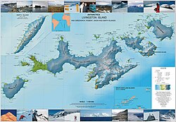
Topographic map of Livingston Island, Greenwich, Robert, Snow and Smith Islands. source ↗

Rugged Rocks (62°37′S 59°48′W / 62.617°S 59.800°W / -62.617; -59.800) is a small group of rocks at the west side of the south entrance to McFarlane Strait, lying just north of Renier Point, Burgas Peninsula on Livingston Island, in the South Shetland Islands. These rocks were known to early sealers in the area and appear on Powell's map of 1822. They were recharted in 1935 by DI personnel on the Discovery II and given this descriptive name.

References

References

 This article incorporates public domain material from "Rugged Rocks". Geographic Names Information System. United States Geological Survey.