Canton de Roxton | |
|---|---|
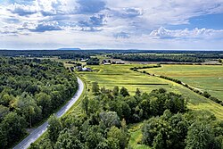 | |
 Seal | |
 Location within Acton RCM | |
Canton de Roxton Location in southern Quebec | |
| Coordinates: 45°33′N 72°31′W / 45.550°N 72.517°W / 45.550; -72.5171 | |
| Country | Canada |
| Province | Quebec |
| Region | Montérégie |
| RCM | Acton |
| Designated | 1795 |
| Proclaimed | 1803 |
| Municipally constituted | July 1, 1855 |
| Named after | Roxton, Bedfordshire1 |
| Government | |
| • Mayor | Stéphane Beauregard |
| • Federal riding | Saint-Hyacinthe—Bagot |
| • Prov. riding | Daniel-Johnson (effective July 15, 2026) |
| Area | |
• Total | 150.10 km2 (57.95 sq mi) |
| • Land | 149.08 km2 (57.56 sq mi) |
| Population (2011)4 | |
• Total | 1,093 |
| • Density | 7.3/km2 (19/sq mi) |
| • Pop 2006-2011 |  7.6% 7.6% |
| • Dwellings | 454 |
| Time zone | UTC−5 (EST) |
| • Summer (DST) | UTC−4 (EDT) |
| Postal code(s) | J0H 1E0 |
| Area codes | 450 and 579 |
| Highways |  R-139 R-139  R-222 R-222  R-241 R-241 |
| Website | cantonderoxton.qc.ca |
Le Canton de Roxton is a township municipality (municipalité de canton) in the Acton Regional County Municipality, in the province of Quebec, Canada. The municipality was designated in 1795, proclaimed in 1803, and officially constituted on July 1, 1855. The population as of the Canada 2011 Census was 1,093.
Le Canton de Roxton has its own distinct municipal administration and elected officials, independent from the neighbouring village of Roxton Falls.
Le Canton de Roxton has only a few hundred fewer people than Roxton Falls, but is spread out over a much greater geographic area.
Demographics
In the 2021 Census of Population conducted by Statistics Canada, Roxton had a population of 1,115 living in 445 of its 483 total private dwellings, a change of 2.7% from its 2016 population of 1,086. With a land area of 148.93 km2 (57.50 sq mi), it had a population density of 7.5/km2 (19.4/sq mi) in 2021.5
Population trend:6
| Census | Population | Change (%) |
|---|---|---|
| 2011 | 1,093 | 7.6%
|
| 2006 | 1,016 |  2.4% 2.4%
|
| 2001 | 1,041 | 6.7%
|
| 1996 | 1,116 | 0.4%
|
| 1991 | 1,120 | N/A |
Mother tongue language (2006)7
| Language | Population | Pct (%) |
|---|---|---|
| French only | 970 | 96.04% |
| English only | 30 | 2.97% |
| Both English and French | 10 | 0.99% |
| Other languages | 0 | 0.00% |
References
References
- "Banque de noms de lieux du Québec: Reference number 54919". toponymie.gouv.qc.ca (in French). Commission de toponymie du Québec.
- Ministère des Affaires municipales, des Régions et de l'Occupation du territoire: Canton de Roxton
- Parliament of Canada Federal Riding History: SAINT-HYACINTHE--BAGOT (Quebec)
- 2011 Statistics Canada Census Profile: Canton de Roxton, Quebec
- "Population and dwelling counts: Canada, provinces and territories, and census subdivisions (municipalities), Quebec". Statistics Canada. February 9, 2022. Retrieved August 28, 2022.
- Statistics Canada: 1996, 2001, 2006, 2011 census
- 2006 Statistics Canada Community Profile: Roxton, Quebec
External links
External links
- Media related to Roxton, Quebec at Wikimedia Commons
- Regional County Municipality of Acton
- Official Site - Roxton Canton (Roxton Township)
- Official Site - Roxton Falls