Roumare | |
|---|---|
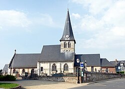 The church in Roumare | |
 Location of Roumare | |
Roumare Roumare | |
| Coordinates: 49°30′41″N 0°58′28″E / 49.5114°N 0.9744°E / 49.5114; 0.9744 | |
| Country | France |
| Region | Normandy |
| Department | Seine-Maritime |
| Arrondissement | Rouen |
| Canton | Notre-Dame-de-Bondeville |
| Government | |
| • Mayor (2023–2026) | Jean-Paul Couiller1 |
Area 1 | 9.96 km2 (3.85 sq mi) |
| Population (2023)2 | 1,560 |
| • Density | 157/km2 (406/sq mi) |
| Time zone | UTC+01:00 (CET) |
| • Summer (DST) | UTC+02:00 (CEST) |
| INSEE/Postal code | 76541 /76480 |
| Elevation | 8–136 m (26–446 ft) (avg. 150 m or 490 ft) |
| 1 French Land Register data, which excludes lakes, ponds, glaciers > 1 km2 (0.386 sq mi or 247 acres) and river estuaries. | |
Roumare (French pronunciation: [ʁumaʁ]) is a commune in the Seine-Maritime department in the Normandy region in northern France.
Geography
A village of forestry and farming situated in the pays de Caux, just 6 miles (9.7 km) northeast of Rouen at the junction of the D47, D90 and the D67 roads. The junction of the A150 autoroute with the A151 lies entirely within the commune's territory.
Population
| Year | Pop. | ±% p.a. |
|---|---|---|
| 1968 | 464 | — |
| 1975 | 608 | +3.94% |
| 1982 | 809 | +4.16% |
| 1990 | 965 | +2.23% |
| 1999 | 1,103 | +1.50% |
| 2007 | 1,348 | +2.54% |
| 2012 | 1,426 | +1.13% |
| 2017 | 1,508 | +1.12% |
| 2023 | 1,560 | +0.57% |
| Source: INSEE3 | ||
Places of interest
- The church of Notre-Dame, dating from the fifteenth century.
- The sixteenth-century château and its chapel.
References
References
- "Répertoire national des élus: les maires" (in French). data.gouv.fr, Plateforme ouverte des données publiques françaises. 16 April 2024.
- "Populations de référence 2023" (in French). National Institute of Statistics and Economic Studies. 18 December 2025.
- Population municipale entre 1968 et 2023, INSEE