| Ter | |
|---|---|
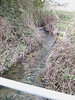 River Ter near Willows Green | |
 | |
| Location | |
| Country | England |
| Region | Essex |
| Physical characteristics | |
| Source | |
| • location | Great Saling |
| • coordinates | 51°53′30″N 0°27′33″E / 51.8917°N 0.4592°E / 51.8917; 0.4592 |
| • elevation | 79 m (259 ft) |
| Mouth | Chelmer and Blackwater Navigation |
• location | near Ulting |
• coordinates | 51°45′01″N 0°35′55″E / 51.7503°N 0.5987°E / 51.7503; 0.5987 |
• elevation | 9 m (30 ft) |
| Length | 27.5 km (17.1 mi) |
| Basin features | |
| River system | Chelmer and Blackwater Navigation |
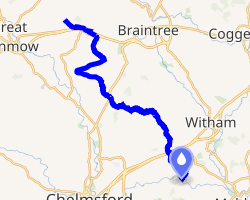
The River Ter is a river in Essex, England. The river rises in Stebbing Green and flowing via Terling it joins the Chelmer and Blackwater Navigation at TL794089 near Rushes Lock. A small part of it, the River Ter SSSI near Great Leighs, has been a geological Site of Special Scientific Interest since 1994.12
-
 River Ter near Willows Green
References
References
- "River Ter citation" (PDF). Sites of Special Scientific Interest. Natural England. Archived from the original (PDF) on 4 March 2016. Retrieved 9 October 2013.
- "Map of River Ter". Sites of Special Scientific Interest. Natural England. Retrieved 9 October 2013.