| Rennington | |
|---|---|
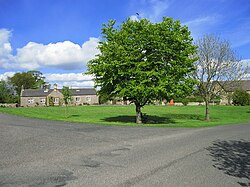 Rennington Village Green | |
Rennington Location within Northumberland | |
| Population | 336 (2011 census)1 |
| OS grid reference | NU 213 185 |
| Civil parish |
|
| Unitary authority | |
| Ceremonial county | |
| Region | |
| Country | England |
| Sovereign state | United Kingdom |
| Post town | ALNWICK |
| Postcode district | NE66 |
| Police | Northumbria |
| Fire | Northumberland |
| Ambulance | North East |
| UK Parliament | |
Rennington is a village and civil parish in Northumberland, England about 4 miles (6 km) north of Alnwick. The parish includes the village of Rock and the hamlets of Broxfield and Stamford. In 2011 the parish had a population of 366.
Governance
Rennington is in the parliamentary constituency of Berwick-upon-Tweed. From 1974 to 2009 it was in Alnwick district.
Rennington was formerly a township and chapelry in the parish of Embleton,2 in 1866 Rennington became a separate civil parish, on 1 April 1955 the parishes of Broxfield, Rock and Stamford were abolished and merged with Rennington.3
References
References
- "Parish population 2011". Retrieved 29 June 2015.
- "History of Rennington, in Alnwick and Northumberland". A Vision of Britain through Time. Retrieved 1 January 2024.
- "Relationships and changes Rennington CP/Ch through time". A Vision of Britain through Time. Retrieved 1 January 2024.
External links
External links
Media related to Rennington at Wikimedia Commons
- Rennington: historical and genealogical information at GENUKI.