| Red Kaweah | |
|---|---|
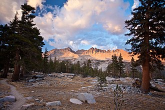 Red Kaweah is the central peak | |
| Highest point | |
| Elevation | 13,726+ ft (4184+ m) NAVD 881 |
| Prominence | 722 ft (220 m)1 |
| Parent peak | Mount Kaweah1 |
| Listing |
|
| Coordinates | 36°32′23″N 118°30′20″W / 36.5396605°N 118.5056486°W / 36.5396605; -118.50564864 |
| Geography | |
 | |
| Location | Tulare County, California, U.S. |
| Parent range | Great Western Divide, Sierra Nevada |
| Topo map | USGS Triple Divide Peak |
| Climbing | |
| First ascent | 1912 by Charles Michael5 |
| Easiest route | Technical Climb, class 45 |
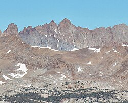
Red Kaweah is a mountain in California's Sequoia National Park on the Kaweah Peaks Ridge. It is 1.8 miles (2.9 km)6 north of Mount Kaweah and 0.7 miles (1.1 km)7 south of Black Kaweah.
References
References
- "Red Kaweah, California". Peakbagger.com. Retrieved August 27, 2009.
- "Sierra Peaks Section List" (PDF). Angeles Chapter, Sierra Club. Retrieved August 27, 2009.
- "Western States Climbers Qualifying Peak List". Climber.org. Retrieved March 26, 2016.
- "Red Kaweah". Geographic Names Information System. United States Geological Survey, United States Department of the Interior. Retrieved August 27, 2009.
- Roper, Steve (1976). The Climber's Guide to the High Sierra. San Francisco: Sierra Club Books. pp. 282, 364. ISBN 978-0871561473.
- "Distance and Bearing between two coordinates". Geody. Retrieved August 27, 2009.
- "Distance and Bearing between two coordinates". Geody. Retrieved August 27, 2009.