Rantabe | |
|---|---|
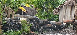 Rosewood lodges at Rantabe waterline | |
Rantabe Location in Madagascar | |
| Coordinates: 15°42′S 49°39′E / 15.700°S 49.650°E / -15.700; 49.650 | |
| Country |  Madagascar Madagascar |
| Region | Ambatosoa |
| District | Maroantsetra |
| Elevation | 17 m (56 ft) |
| Population (2001)2 | |
• Total | 20,000 |
| Time zone | UTC+3 (EAT) |
| Postal code | 512 |
Rantabe is a rural commune in Ambatosoa, Madagascar. It belongs to the district of Maroantsetra. The population of the commune was estimated to be approximately 20,000 in the 2001 commune census.2
Rantabe has a riverine harbour. Primary and junior level secondary education are available in town. The majority 82% of the population of the commune are farmers. The most important crops are rice and vanilla, while other important agricultural products are coffee and cloves. Services provide employment for 12% of the population. Additionally fishing employs 6% of the population.2
Roads
The town is situated at the N5 road, south of the mouth of the Rantabe River into the Indian Ocean.
Nature
References
References
- Estimated based on DEM data from Shuttle Radar Topography Mission
- "ILO census data". Cornell University. 2002. Retrieved 2008-03-08.