Rangdum | |
|---|---|
Village | |
 Rangdum | |
 Interactive map of Rangdum | |
Rangdum Location in Ladakh, India Show map of LadakhRangdum Rangdum (India) Show map of India | |
| Coordinates: 34°03′21″N 76°19′30″E / 34.0558°N 76.3249°E / 34.0558; 76.3249 | |
| Country | |
| Union territory | Ladakh |
| District | Kargil |
| Tehsil | Taisuru1 |
| Elevation | 3,657 m (11,998 ft) |
| Languages | |
| • Official | Hindi, English |
| • Spoken | Ladakhi, Purgi, Urdu |
| Time zone | UTC+5:30 (IST) |
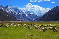
Rangdum is a village located in the Suru Valley of kargil district in the union territory of Ladakh in Northern India. On one side are the colourful hills while on the other side are rocky mountains and glaciers, notably Drang-drung.
It is located on the NH301 Kargil-Padum Highway.2345
Geography
Rangdum is located midway between Kargil and Padum. It is about 100 kilometres (62 mi) from Kargil.
"Rangdum, with its gompa and the attendant village of Juliodok, is the last inhabited region in the Suru valley; it is also the destination of the nomadic herds people called Bakarwals, who trek up every year from the Himalayan foothills near Jammu, bringing their flocks of sheep and goats to grow fat on the rich summer growth of grass. From Rangdum the valley rises to 4400 metres and the Pensi-la, the gateway into Zanskar."6
The country surrounding Rangdum Monastery is very bleak and crops sometimes cannot ripen in the brief summer. The locals depend on their flocks and supplies from lower down the Suru Valley or over the pass from Zanskar.7
Demography
The population of the Suru Valley as far as Parkachik are all Muslim. The valley is, however, practically uninhabited past Parkachik other than a couple of tiny settlements. The small villages of Yuldo and Julidok, at the end of the valley, are entirely Buddhist. The people are socially and culturally part of neighbouring Zanskar and support the 18th-century Rangdum Monastery belonging to the Gelugpa sect of Tibetan Buddhism.89
Tourism
Rangdum has a tourist bungalow, three tea-houses and, around 2 km from the village, a summer-only camp offering accommodation for tourists in bedded tents.10
References
References
- Janet Rizvi. (1996). Ladakh: Crossroads of High Asia. Second Edition. Oxford University Press, Delhi. ISBN 0-19-564546-4.
- Schettler, Margaret & Rolf (1981). Kashmir, Ladakh & Zanskar. Lonely Planet Publications. South Yarra, Victoria, Australia. ISBN 0-908086-21-0.
- "Villages in Kargil district". Kargil district website. Retrieved 1 May 2020.
- "New highways notification dated August, 2012" (PDF). The Gazette of India - Ministry of Road Transport and Highways. Retrieved 12 July 2018.
- "New Numbering of National Highways notification - Government of India" (PDF). The Gazette of India. Retrieved 12 July 2018.
- "State-wise length of National Highways (NH) in India as on 30.06.2017". Ministry of Road Transport and Highways. Retrieved 12 July 2018.
- "Centre announces 8 new Highways for J&K". Daily Excelsior. 25 July 2015. Retrieved 12 July 2018.
- Rizvi (1996), p. 28.
- Rizvi (1996), p. 29.
- Rizvi (1996), pp. 29, 253.
- Schettler, Margaret & Rolf (1981), p. 150.
- Lonely Planet India guide, 12th edition