Rabenwald | |
|---|---|
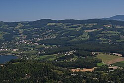 Aerial view with Rabenwald in the background | |
 Coat of arms | |
Rabenwald Location within Austria | |
| Coordinates: 47°18′10″N 15°47′51″E / 47.30278°N 15.79750°E / 47.30278; 15.79750 | |
| Country | Austria |
| State | Styria |
| District | Hartberg-Fürstenfeld |
| Area | |
• Total | 16.91 km2 (6.53 sq mi) |
| Elevation | 520 m (1,710 ft) |
| Population (1 January 2016)1 | |
• Total | 604 |
| • Density | 35.7/km2 (92.5/sq mi) |
| Time zone | UTC+1 (CET) |
| • Summer (DST) | UTC+2 (CEST) |
| Postal code | 8225 |
| Area code | 03335 |
| Vehicle registration | HB |
| Website | www.rabenwald. steiermark.at |
Rabenwald is a former municipality in the district of Hartberg-Fürstenfeld in Styria, Austria. Since the 2015 Styria municipal structural reform, it is part of the municipality Pöllau.2
References
References