Qir
Persian: قير | |
|---|---|
City | |
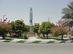 Shohada square | |
Qir | |
| Coordinates: 28°29′01″N 53°02′12″E / 28.48361°N 53.03667°E / 28.48361; 53.036671 | |
| Country | Iran |
| Province | Fars |
| County | Qir and Karzin |
| District | Central |
| Elevation | 771 m (2,530 ft) |
| Population (2016)2 | |
• Total | 20,010 |
| Time zone | UTC+3:30 (IRST) |
Qir (Persian: قير)a is a city in the Central District of Qir and Karzin County, Fars province, Iran, serving as capital of both the county and the district.4 The city has an altitude of 771 metres (2,530 ft).5
History
On 10 April 1972, Qir was destroyed by a large earthquake, killing 3,399 people, two-thirds of the population at that time.6: 128
Demographics
Population
At the time of the 2006 National Census, the city's population was 16,839 in 3,722 households.7 The following census in 2011 counted 18,038 people in 4,603 households.8 The 2016 census measured the population of the city as 20,010 people in 5,650 households.2
References
References
- OpenStreetMap contributors (9 October 2024). "Qir, Qir and Karzin County" (Map). OpenStreetMap (in Persian). Retrieved 9 October 2024.
- Census of the Islamic Republic of Iran, 1395 (2016): Fars Province. amar.org.ir (Report) (in Persian). The Statistical Center of Iran. Archived from the original (Excel) on 6 April 2022. Retrieved 19 December 2022.
- Qir at GEOnet Names Server
- Aref, Mohammad Reza (c. 2021) [Approved 18 July 1380]. Approval letter regarding the changes and reforms of divisions in Fars province. rc.majlis.ir (Report) (in Persian). Ministry of the Interior, Council of Ministers. Proposal 1.4.42.19063. Archived from the original on 9 October 2021. Retrieved 10 December 2023 – via Islamic Council Research Center.
- Location of Qir - Falling Rain Genomics
- Razani, R.; Lee K.L. (1973). The Engineering Aspects of the Qir Earthquake of 10 April 1972 in Southern Iran. National Academy of Sciences. p. 144. Retrieved 28 July 2012.
- Census of the Islamic Republic of Iran, 1385 (2006): Fars Province. amar.org.ir (Report) (in Persian). The Statistical Center of Iran. Archived from the original (Excel) on 20 September 2011. Retrieved 25 September 2022.
- Census of the Islamic Republic of Iran, 1390 (2011): Fars Province. irandataportal.syr.edu (Report) (in Persian). The Statistical Center of Iran. Archived from the original (Excel) on 16 January 2023. Retrieved 19 December 2022 – via Iran Data Portal, Syracuse University.