Potelle | |
|---|---|
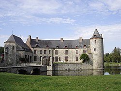 The chateau in Potelle | |
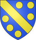 Coat of arms | |
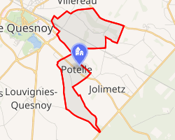 Location of Potelle | |
Potelle Potelle | |
| Coordinates: 50°14′06″N 3°39′51″E / 50.235°N 3.6642°E / 50.235; 3.6642 | |
| Country | France |
| Region | Hauts-de-France |
| Department | Nord |
| Arrondissement | Avesnes-sur-Helpe |
| Canton | Avesnes-sur-Helpe |
| Intercommunality | Pays de Mormal |
| Government | |
| • Mayor (2023–2026) | Vincent Dussart1 |
Area 1 | 4.04 km2 (1.56 sq mi) |
| Population (2023)2 | 439 |
| • Density | 109/km2 (281/sq mi) |
| Time zone | UTC+01:00 (CET) |
| • Summer (DST) | UTC+02:00 (CEST) |
| INSEE/Postal code | 59468 /59530 |
| Elevation | 104–147 m (341–482 ft) (avg. 104 m or 341 ft) |
| 1 French Land Register data, which excludes lakes, ponds, glaciers > 1 km2 (0.386 sq mi or 247 acres) and river estuaries. | |
Potelle (French pronunciation: [pɔtɛl]) is a commune in the Nord department in northern France.3
It is 2 km (1.2 mi) east of Le Quesnoy and 15 km (9.3 mi) southeast of Valenciennes.
Heraldry
|
The arms of Potelle are blazoned : Azure, a bend Or between 6 bezants (Or). (Aulnoy-lez-Valenciennes, Bantouzelle, Briastre, Noyelles-sur-Selle and Potelle use the same arms.)
|
References
References
- "Répertoire national des élus: les maires" (in French). data.gouv.fr, Plateforme ouverte des données publiques françaises. 30 November 2023.
- "Populations de référence 2023" (in French). National Institute of Statistics and Economic Studies. 18 December 2025.
- INSEE commune file