42°48′33″N 12°47′07″E / 42.80928°N 12.78535°E / 42.80928; 12.78535 Poreta is a village in the municipality of Spoleto, in the region of Umbria, Italy. As of 2021, it had a population of 143. The village is situated at an elevation of 341 metres (1,119 ft) above sea level.1 It lies between Spoleto, Campello, and the Springs of Clitunno.2
History
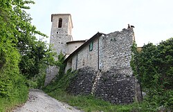
Poreta originated as a villa and became a fortified village toward the end of the 13th century. In the second half of the 15th century, because of repeated raids by mercenary companies, a circuit of walls was built around the older settlement. The result was a compact built-up center of houses joined closely together, which became the focal point of a wider settlement spread across the slope and the plain of Spoleto.2
In the second half of the 18th century, after a violent earthquake, the castle was gradually abandoned. The inhabitants built their houses outside the walls, reusing stones from the destroyed buildings.
Religion and culture
The church of San Cristoforo, built after the castle, was later dedicated to Santa Maria della Misericordia because of a miraculous image of the Madonna kept inside it and said to have remained unharmed by earthquake damage.2
References
References
- "Sezioni di censimento – 10-Umbria". Istat. Retrieved 16 February 2026.
LOC21_ID 5405110014
- "Attrattori turistici". Open Data Umbria. Regione Umbria. Retrieved 26 February 2026. This article incorporates text from this source, which is under a CC BY 4.0 license.