Perkpolder | |
|---|---|
Hamlet | |
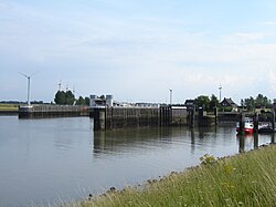 Harbour of Perkpolder | |
 Coat of arms | |
Perkpolder Location in the province of Zeeland in the Netherlands Show map of ZeelandPerkpolder Perkpolder (Netherlands) Show map of Netherlands | |
| Coordinates: 51°24′N 4°01′E / 51.400°N 4.017°E / 51.400; 4.017 | |
| Country | Netherlands |
| Province | Zeeland |
| Municipality | Hulst |
| Area | |
• Total | 2.41 km2 (0.93 sq mi) |
| Elevation | 1.5 m (4.9 ft) |
| Population (2021)1 | |
• Total | 5 |
| • Density | 2.1/km2 (5.4/sq mi) |
| Time zone | UTC+1 (CET) |
| • Summer (DST) | UTC+2 (CEST) |
| Postal code | 45881 |
| Dialing code | 0114 |
Perkpolder is a hamlet in the southwestern Netherlands, situated in the municipality of Hulst, Zeeland. It is known as the departure point for the ferry Kruiningen-Perkpolder that connected Zuid-Beveland and Zeelandic Flanders.3
Polder
The hamlet is named after the polder in which it is located. This polder was dammed around 1210, and was originally named Noorthofpolder, later this was changed in Paerkpolder or Perkpolder. This polder, which has 166 ha area, has two kilometres of dykes.
References
References
- "Kerncijfers wijken en buurten 2021". Central Bureau of Statistics. Retrieved 20 April 2022.
- "Postcodetool for 4588KA". Actueel Hoogtebestand Nederland (in Dutch). Het Waterschapshuis. Archived from the original on 7 January 2019. Retrieved 20 April 2022.
- "Veerdienst Kruiningen-Perkpolder". PSD Net (in Dutch). Retrieved 20 April 2022.