Patamacca | |
|---|---|
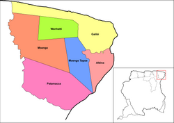 Map showing the resorts of Marowijne District. Patamacca | |
| Country |  Suriname Suriname |
| District | Marowijne District |
| Area | |
• Total | 1,183 km2 (457 sq mi) |
| Population (2012)1 | |
• Total | 427 |
| • Density | 0.361/km2 (0.935/sq mi) |
| Time zone | UTC-3 (AST) |
Patamacca is a resort in Suriname, located in the Marowijne District. Its population at the 2012 census was 427. Patamacca is a tribal area inhabited by Maroons1
In 1773, attempts were made to conquer the Patamacca territory by the Society of Suriname, but did not yield results, and the area was left in the hands of the Maroons.2
The main economic activity in the Patamacca area was the palm oil industry,3 During the 1960s4 Bruynzeel started a large-scale wood plantation in the resort.5 There is a large granite mine in the resort which is operated by Grassalco.6 Even though Patamacca did not bear much destruction during the Surinamese Interior War, the civil war did result in refugees, and stopped much of the industry.4 As of 2019, attempts have been made to restart the palm oil industry with Chinese aid.7
The village of Ovia Olo is located in the resort.8
References
References
- "Resorts in Suriname Census 2012" (PDF). Archived from the original (PDF) on 23 December 2021. Retrieved 21 May 2020.
- "Geschiedenis Van Suriname" (in Dutch). 1861. Retrieved 21 May 2020.
- "Suriname palm-oil industry may rise again after setbacks". The Caribbean Radio. Retrieved 21 May 2020.
- "Distrikt Marowijne 2". Suriname.nu (in Dutch). Archived from the original on 11 August 2019. Retrieved 21 May 2020.
- "HUMAN INTERFERENCE IN THE TROPICAL RAINFOREST ECOSYSTEM". Anton de Kom University via Wageningen University. Retrieved 21 May 2020.
- "Grassalco N.V. Ons bedrijf". Grassalco (in Dutch). Archived from the original on 18 May 2019. Retrieved 21 May 2020.
- "PALMOLIE OF ORDINAIRE HOUTROOF?". Dagblad De West. 8 June 2019. Retrieved 21 May 2020.
- Plan Bureau (2014). "Planning Office Suriname - Districts 2009-2013" (PDF). Planning Office Suriname (in Dutch). p. 114.
5°25′23″N 54°30′07″W / 5.423°N 54.502°W / 5.423; -54.502