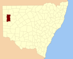
Kayrunnera located at 30°40′49″S 142°24′05″E / 30.680278°S 142.401389°E / -30.680278; 142.401389 is a remote civil parish of Mootwingee County in far North West New South Wales.1
The Geography, of the Parish is mostly a flat, arid landscape. The parish has a Köppen climate classification of BWh (Hot desert).2
References
References
- "Mootwingee County". Geographical Names Register (GNR) of NSW. Geographical Names Board of New South Wales.
- Peel, M. C.; Finlayson, B. L.; McMahon, T. A. (2007). "Updated world map of the Köppen–Geiger climate classification". Hydrol. Earth Syst. Sci. 11: 1633–1644. doi:10.5194/hess-11-1633-2007. ISSN 1027-5606. (direct: Final Revised Paper)