Panningen
Kepèl | |
|---|---|
Town | |
 | |
Panningen Location in the Netherlands Show map of NetherlandsPanningen Location in the province of Limburg in the Netherlands Show map of Limburg, Netherlands | |
| Coordinates: 51°19′39″N 5°58′54″E / 51.32750°N 5.98167°E / 51.32750; 5.98167 | |
| Country | Netherlands |
| Province | Limburg |
| Municipality | Peel en Maas |
| Area | |
• Total | 45.83 km2 (17.70 sq mi) |
| Elevation | 34 m (112 ft) |
| Population (2021)1 | |
• Total | 6,910 |
| • Density | 151/km2 (391/sq mi) |
| Time zone | UTC+1 (CET) |
| • Summer (DST) | UTC+2 (CEST) |
| Postal code | 59811 |
| Dialing code | 077 |
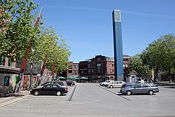
Panningen (Dutch: [ˈpɑnɪŋə(n)]; Limburgish: Kepèl) is a Dutch town with a population of 7,618 inhabitants (2020)3 and is the biggest settlement of the municipality Peel en Maas. It is centrally located between the cities of Roermond, Weert and Venlo in the north of the Dutch province Limburg. Before the 2010 municipal redivision, when Panningen became a part of the newly formed municipality of Peel en Maas, it was part of Helden. Together with Helden, Panningen forms a double core, the double core Helden-Panningen has 13,863 inhabitants (2020).3 Its nearest city, Venlo, lies about 13 km eastwards.
The built-up area of the town is 3.38 km², and contains 4,523 residences.4
Sports
The local handball team Bevo HC has won the Dutch Championship once, in 2014.
Education
Bouwens van der Boijecollege is a public highschool in this town.
Gallery
-
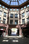 Shopping mall De Pit
 -
 Brick works
References
References
- "Kerncijfers wijken en buurten 2021". Central Bureau of Statistics. Retrieved 25 April 2022.
- "Postcodetool for 5981AA". Actueel Hoogtebestand Nederland (in Dutch). Het Waterschapshuis. Archived from the original on 21 September 2013. Retrieved 25 April 2022.
- "Number of inhabitants per village Peel en Maas". Peel en Maas.
- Statistics Netherlands (CBS), Bevolkingskernen in Nederland 2001 [1] Archived 2007-01-24 at the Wayback Machine. Statistics are for the continuous built-up area.