Otakeho | |
|---|---|
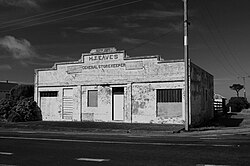 1928 store of Hubert James Eaves | |
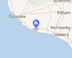 Interactive map of Otakeho | |
| Coordinates: 39°32′56″S 174°02′24″E / 39.549°S 174.040°E / -39.549; 174.040 | |
| Country | New Zealand |
| Region | Taranaki |
| Territorial authority | South Taranaki District |
| Ward |
|
| Community |
|
| Electorates | |
| Government | |
| • Territorial Authority | South Taranaki District Council |
| • Regional council | Taranaki Regional Council |
| • Mayor of South Taranaki | Phil Nixon3 |
| • Whanganui MP | Carl Bates4 |
| • Te Tai Hauāuru MP | Debbie Ngarewa-Packer5 |
| Area | |
• Total | 31.46 km2 (12.15 sq mi) |
| Population (2023 Census)2 | |
• Total | 177 |
| • Density | 5.63/km2 (14.6/sq mi) |
Otakeho, meaning place of Takeho,6 is a locality in southern Taranaki, New Zealand, west of the Otakeho Stream (rising on Mount Taranaki and reaching the Tasman Sea at Otakeho.7 It is on SH45.8
It has a hall (built in 1897 to celebrate Queen Victoria's Diamond Jubilee),9 a boarded up store10 (taken over by H J Eaves in 1904,11 when it sold a wide variety of groceries, ironmongery, drapery, boots,12 farm, garden, sporting and household goods.1314 It burnt down in July 19271516 and was rebuilt about April 1928)17 a war memorial18 and a few houses.
3.8 km (2.4 mi) west of Otakeho19 is Ngāruahine's Tawhitinui Marae.20 A kohanga reo has been run at the marae since the 1980s.21
Otakeho has a small sandy beach, beyond Dingle Road,22 at the foot of 40 m (130 ft) high cliffs.23 It is used for fishing22 and has a poorly protected,24 nationally threatened, variety of Craspedia, Craspedia Otakeho.25
The Ōpunake to New Plymouth bus runs through Otakeho daily in each direction, except at weekends.26 A bus has run since 191527 and was preceded by Royal Mail coaches,2829 which changed horses there from 1881.30
History
Otakeho was, like Parihaka, a part of the Waimate Plains confiscated from Ngāti Ruanui under the Settlements Act 1863,31 so that precautions were taken during the survey of the main road in 1878.32 In 1880 there was a camp of No.1 Company of the Armed Constabulary at Otakeho, when the road was being built.3334 Later in the year the confiscated land was being sold,35 for £16 to £24 per acre.36 Otakeho may have been an area where ploughing protests occurred,37 though it stopped on request.38 A phone line to Manaia was built about 1883.39 Otakeho Bridge was swept away by a flood in 1893.40 Gravel was put on the mud roads around the period 189341 to 1913.42
Growth
Otakeho grew from the 1880s to the early decades of the twentieth century, becoming a much larger village than the current one, its first store, bakery and post and telegraph office being opened by Mr Blennerhasset in 1882 (his murder in a neighbours' dispute in 1901 briefly put Otakeho in the headlines).43444546 In 1883 a butcher and smithy opened, a school in 1884, a tinsmith's and in 1896 a public hall. A debating society was formed in 1891.47 The 1894 school48 closed in 2003,18 though the buildings remain.49 An 1893 Category 2 listed church was designed by Frederick de Jersey Clere,50 was extended with a vestry in 1954,51 closed in 2015, deconsecrated in 2017,52 sold in 201853 and moved to Pihama in 2021.50 The churchyard wasn't used as a burial ground.54 The village also had carriers,5556 a dairy factory,57 which occupied several buildings58 and three butchers.59
Hotel
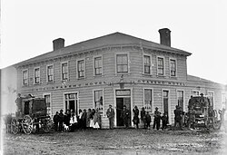
Tenders for the hotel were invited in 1881,60 building started in September 1881,61 and the 20-room62 Otakeho Hotel opened in January 1882.63 It was rebuilt64 after a 1907 fire65 and burnt down again66 in January 1980.67
Dairy
In 1888 Newton King together with R. Cook and J.C. George founded the Crown Dairy Company which started by taking over three unsuccessful co-operatives at Manaia, Otakeho and Opunake.5968
Demographics
Otakeho locality covers 31.46 km2 (12.15 sq mi).1 The locality is part of the larger Taungatara statistical area.69
The population was once almost double the current total, being 75 in 1906,70 314 in 192171 and 305 in 1951.72
| Year | Pop. | ±% p.a. |
|---|---|---|
| 2006 | 219 | — |
| 2013 | 189 | −2.08% |
| 2018 | 198 | +0.93% |
| 2023 | 177 | −2.22% |
| Source: 273 | ||
Otakeho had a population of 177 in the 2023 New Zealand census, a decrease of 21 people (−10.6%) since the 2018 census, and a decrease of 12 people (−6.3%) since the 2013 census. There were 93 males and 84 females in 66 dwellings.74 3.4% of people identified as LGBTIQ+. The median age was 34.6 years (compared with 38.1 years nationally). There were 39 people (22.0%) aged under 15 years, 36 (20.3%) aged 15 to 29, 84 (47.5%) aged 30 to 64, and 18 (10.2%) aged 65 or older.2
People could identify as more than one ethnicity. The results were 88.1% European (Pākehā), 23.7% Māori, 1.7% Pasifika, 1.7% Asian, and 3.4% other, which includes people giving their ethnicity as "New Zealander". English was spoken by 100.0%, Māori by 5.1%, and other languages by 3.4%. No language could be spoken by 1.7% (e.g. too young to talk). New Zealand Sign Language was known by 1.7%. The percentage of people born overseas was 10.2, compared with 28.8% nationally.2
Religious affiliations were 28.8% Christian. People who answered that they had no religion were 57.6%, and 11.9% of people did not answer the census question.2
Of those at least 15 years old, 12 (8.7%) people had a bachelor's or higher degree, 84 (60.9%) had a post-high school certificate or diploma, and 45 (32.6%) people exclusively held high school qualifications. The median income was $46,800, compared with $41,500 nationally. 18 people (13.0%) earned over $100,000 compared to 12.1% nationally. The employment status of those at least 15 was 78 (56.5%) full-time, 30 (21.7%) part-time, and 6 (4.3%) unemployed.2
Notable people
- Margaret Jane Briggs (17 April 1892 – 5 November 1961) a show‑ring rider born in Otakeho
- Sir William Hudleston le Fleming, 9th Baronet (1861–1945) member of Waimate Road Board, then Waimate West County Council (1886-1923), dairy company director, hall committee chairman for 15 years and school committee for 12 years, a director of Kaupokonui Co-operative Dairy Co for 14 years, and a member of Otakeho Farmers' Union75
- Frederick Arthur Lye (1881 – 3 October 1949) a Liberal and United MP (1922-35), who farmed at Otakeho from 1906 to 1918
- William Sheridan (12 March 1858 – 16 November 1931) a Tasmanian Labour MP (1909-28), who ran a store at Otakeho, from 1900 until sold to his brother in law, H J Eaves in 1904
See also
See also
References
References
- "Stats NZ Geographic Data Service". Statistical Area 1 2023 (generalised). Retrieved 11 November 2025.
- "Totals by topic for individuals, (RC, TALB, UR, SA3, SA2, Ward, Health), 2013, 2018, and 2023 Censuses". Stats NZ – Tatauranga Aotearoa – Aotearoa Data Explorer. 7017386. Retrieved 3 October 2024.
- "Declaration of Results of Election and Poll" (PDF). South Taranaki District Council. 17 October 2025.
- "Whanganui - Official Result". Electoral Commission. Retrieved 5 October 2025.
- "Te Tai Hauāuru - Official Result". Retrieved 20 April 2025.
- "Otakeho | NZ History". nzhistory.govt.nz. Retrieved 13 November 2025.
- "Otakeho Water Quantity Data". Land, Air, Water Aotearoa (LAWA). Retrieved 9 January 2022.
- "Geographic Boundary Viewer". statsnz.maps.arcgis.com. Archived from the original on 9 January 2022. Retrieved 9 January 2022.
- Ron. "Otakeho Hall - 1897". ketenewplymouth.peoplesnetworknz.info. Retrieved 9 January 2022.
- "2071 South Rd Otakeho, Taranaki". Google Maps. June 2021. Archived from the original on 9 January 2022. Retrieved 9 January 2022.
- "Impressions of Tasmania. Taranaki Daily News". paperspast.natlib.govt.nz. 7 March 1929. Retrieved 10 November 2025.
- "The Cyclopedia of New Zealand (Taranaki". ndhadeliver.natlib.govt.nz. 1908. Retrieved 13 November 2025.
- "Hawera & Normanby Star". paperspast.natlib.govt.nz. 29 October 1908. Retrieved 13 November 2025.
- "Hawera & Normanby Star". paperspast.natlib.govt.nz. 5 July 1913. Retrieved 13 November 2025.
- PhilBee NZ (social historian) (6 March 2021), Otakeho: HJ Eaves’ general store (c.1928)(1), retrieved 10 November 2025
- "Blaze at Otakeho. Hawera Star". paperspast.natlib.govt.nz. 23 July 1927. Retrieved 10 November 2025.
- "Hawera Star". paperspast.natlib.govt.nz. 26 April 1928. Retrieved 10 November 2025.
- "Otakeho war memorial". nzhistory.govt.nz. Retrieved 9 January 2022.
- "2071 South Road to Tawhtinui Marae". Google maps. Retrieved 13 November 2025.
- "Tawhitinui Marae". Archived from the original on 22 April 2017.
- "Tawhitinui Marae". Toi Foundation. Retrieved 13 November 2025.
- "Inventory of coastal areas of local or regional significance in the Taranaki Region" (PDF). January 2004. Archived (PDF) from the original on 21 April 2017.
- "Otakeho Stream, Taranaki". NZ Topo Map. Retrieved 9 January 2022.
- "The Taranaki Inc Biodiversity Strategy" (PDF). Archived (PDF) from the original on 18 April 2017.
- "New Zealand Flora". nzflora.landcareresearch.co.nz. Retrieved 9 January 2022.
- "Hāwera-New Plymouth (extending from Ōpunake first service)". July 2021. Archived from the original on 9 January 2022.
- "Hawera & Normanby Star". paperspast.natlib.govt.nz. 21 July 1915. Retrieved 12 November 2025.
- "Opunake Times". paperspast.natlib.govt.nz. 4 June 1915. Retrieved 12 November 2025.
- "Hawera & Normanby Star". paperspast.natlib.govt.nz. 27 August 1892. Retrieved 13 November 2025.
- "The Waimate Plains. Hawera & Normanby Star". paperspast.natlib.govt.nz. 5 February 1881. Retrieved 13 November 2025.
- "West Coast 1880 plan of the confiscated territory". kura.aucklandlibraries.govt.nz. Retrieved 11 November 2025.
- "No. 8. Major Brown, Civil Commissioner, Taranaki, to the Under Secretary, Native Department". paperspast.natlib.govt.nz. 10 August 1878. Retrieved 11 November 2025.
- "Waimate Plains. Rapid advance of the roadmaking. Evening Post". paperspast.natlib.govt.nz. 28 April 1880. Retrieved 11 November 2025.
- "Special telegrams. Thames Advertiser". paperspast.natlib.govt.nz. 2 April 1880. Retrieved 13 November 2025.
- "News and notes. Hawera & Normanby Star". paperspast.natlib.govt.nz. 15 December 1880. Retrieved 11 November 2025.
- "Latest Wellington news. New Zealand Herald". paperspast.natlib.govt.nz. 22 December 1880. Retrieved 11 November 2025.
- "Hawera. Daily Telegraph (Napier)". paperspast.natlib.govt.nz. 1 October 1881. Retrieved 11 November 2025.
- "The Maori difficulty. New Zealand Herald". paperspast.natlib.govt.nz. 30 September 1881. Retrieved 12 November 2025.
- "News and notes. Hawera & Normanby Star". paperspast.natlib.govt.nz. 17 October 1883. Retrieved 13 November 2025.
- "The Northern Floods. Southland Times". paperspast.natlib.govt.nz. 14 March 1893. Retrieved 13 November 2025.
- "Otakeho. Hawera & Normanby Star". paperspast.natlib.govt.nz. 19 April 1893. Retrieved 13 November 2025.
- "Waimate West County Council. Hawera & Normanby Star". paperspast.natlib.govt.nz. 12 September 1913. Retrieved 13 November 2025.
- "The Otakeho tragedy. Opunake Times". paperspast.natlib.govt.nz. 3 January 1902. Retrieved 13 November 2025.
- "The scene of the Otakeho murder. Auckland Weekly News". kura.aucklandlibraries.govt.nz. 16 January 1902. Retrieved 13 November 2025.
- "The residence of Mr W H Blennnerhassett. Auckland Weekly News". kura.aucklandlibraries.govt.nz. 16 January 1902. Retrieved 13 November 2025.
- "Mr W Hill who shot dead Mr W A Blennerhassett and son. Auckland Weekly News". kura.aucklandlibraries.govt.nz. 9 January 1902. Retrieved 13 November 2025.
- "Founding of township. Taranaki Daily News". paperspast.natlib.govt.nz. 3 May 1934. Retrieved 13 November 2025.
- "EDUCATIONAL MILESTONE. HAWERA STAR". paperspast.natlib.govt.nz. 4 May 1934. Archived from the original on 9 January 2022. Retrieved 9 January 2022.
- "2121 South Rd Otakeho, Taranaki". Google Maps. February 2010. Archived from the original on 11 January 2022. Retrieved 9 January 2022.
- "St John the Divine Church (Former) [Relocated]". www.heritage.org.nz. Retrieved 10 November 2025.
- Bruce Dickson Architecture (May 2020). "St. John the Divine Historic Church 4 Campbell Road – Otakeho" (PDF).
- "St John's memorials, Otakeho | NZ History". nzhistory.govt.nz. 6 November 2024. Retrieved 13 November 2025.
- "Otakeho church tender offers closed, attracts a flurry of interest". Stuff. 8 June 2018. Retrieved 9 January 2022.
- Louise McLay (January 2020). "Land Use Consent to Relocate St John the Divine Historic Church" (PDF).
- "Hawera & Normanby Star". paperspast.natlib.govt.nz. 3 December 1892. Retrieved 13 November 2025.
- "Hawera & Normanby Star". paperspast.natlib.govt.nz. 10 February 1922. Retrieved 13 November 2025.
- "Otakeho". nzetc.victoria.ac.nz. 1908. Archived from the original on 9 December 2012. Retrieved 9 January 2022.
- Ron. "T.L. Joll Co-op - Otakeho Factory". ketenewplymouth.peoplesnetworknz.info. Retrieved 9 January 2022.
- G.I. Rawson (1967). "The evolution of the rural settlement pattern of lowland south Taranaki 1860 - 1920". ir.canterbury.ac.nz. Archived from the original on 15 November 2024. Retrieved 12 November 2025.
- "Hawera & Normanby Star". paperspast.natlib.govt.nz. 3 September 1881. Retrieved 13 November 2025.
- "New and notes. Hawera & Normanby Star". paperspast.natlib.govt.nz. 24 September 1881. Retrieved 13 November 2025.
- "Otakeho Hotel. Hawera & Normanby Star". paperspast.natlib.govt.nz. 13 February 1882. Retrieved 13 November 2025.
- "Patea Mail". paperspast.natlib.govt.nz. 4 January 1882. Retrieved 13 November 2025.
- "HAWERA & NORMANBY STAR". paperspast.natlib.govt.nz. 11 January 1908. Archived from the original on 9 January 2022. Retrieved 9 January 2022.
- "FIRE AT OTAKEHO. HAWERA & NORMANBY STAR". paperspast.natlib.govt.nz. 2 August 1907. Archived from the original on 11 January 2022. Retrieved 9 January 2022.
- "Nicholls Story Farming Agricultural Vetenarian Scholarships BA Taranaki". Bashford-Nicholls Trust. Retrieved 9 January 2022.
- "Four escape fire. Press". paperspast.natlib.govt.nz. 16 January 1980. Retrieved 13 November 2025.
- "Our industries and trades. Taranaki Herald". paperspast.natlib.govt.nz. 24 November 1894. Retrieved 13 November 2025.
- "Geographic Boundary Viewer". Stats NZ. Statistical Area 1 – 2023 and Statistical Area 2 – 2023.
- "Results of a census of the colony of New Zealand taken for the night of the 29th April, 1906". StatsNZ.
- "1921 census". statsnz.contentdm.oclc.org. p. 49. Retrieved 10 November 2025.
- "1951 census". statsnz.contentdm.oclc.org. p. 95. Retrieved 10 November 2025.
- "Statistical area 1 dataset for 2018 Census". Statistics New Zealand. March 2020. 7017386.
- "Totals by topic for dwellings, (RC, TALB, UR, SA3, SA2, Ward, Health), 2013, 2018, and 2023 Censuses". Stats NZ – Tatauranga Aotearoa – Aotearoa Data Explorer. Retrieved 3 October 2024.
- "District's Tribute To Sir William le Fleming's Service. Taranaki Daily News". paperspast.natlib.govt.nz. 20 November 1945. Retrieved 12 November 2025.