Orior Lower
| |
|---|---|
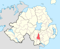 Location of Orior Lower, County Armagh, Northern Ireland. | |
| Sovereign state | United Kingdom |
| Country | Northern Ireland |
| County | Armagh |
Orior Lower (from Irish: Airthir, the name of an ancient Gaelic territory)23 is a barony in County Armagh, Northern Ireland.4 It lies in the east of the county and borders County Down with its eastern boundary. It is bordered by seven other baronies: Fews Upper to the south-west; Fews Lower to the west; Oneilland West to the north-west; Oneilland East to the north; Iveagh Lower, Lower Half to the north-east; Iveagh Upper, Upper Half to the east; and Orior Upper to the south. A small enclave of Orior Lower resides in the east of Orior Upper.4
List of main settlements
Below is a list of settlements within Orior Lower:1
Towns
Villages and population centres
- Eleven Lane Ends
- Clare
- Forkhill
- Poyntzpass (split with Iveagh Upper, Upper Half)
- Jerrettspass
- Laurelvale
- Loughgilly (also part in the baronies of Fews Lower and Orior Upper)
List of civil parishes
Below is a list of civil parishes in Orior Lower:56
- Ballymore
- Forkill
- Killevy (split with barony of Orior Upper)
- Kilmore (split with barony of Oneilland West, not be confused with separate civil parish of Kilmore in County Down)
- Loughgilly (split with baronies of Fews Upper and Orior Upper)
References
References
- "Orior Lower". Placenames Database of Ireland. Department of Community, Rural and Gaeltacht Affairs. Retrieved 8 June 2011.
- Ireland's History in Maps - The Baronies of Ireland
- "Baronies of Armagh". Archived from the original on 13 March 2012. Retrieved 28 September 2010.
- PRONI Baronies of Northern Ireland
- "PRONI Civil Parishes of County Armagh". Archived from the original on 16 May 2008. Retrieved 28 September 2010.
- "Baronies and civil parishes of County Armagh". Archived from the original on 17 February 2010. Retrieved 6 February 2011.