Олюторский полуостров | |
|---|---|
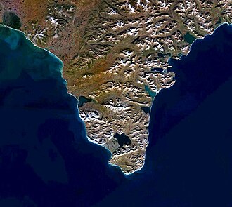 Satellite image of the peninsula | |
Location within Kamchatka Krai Show map of Kamchatka KraiLocation within Far Eastern Federal District Show map of Far Eastern Federal District | |
| Geography | |
| Location | Kamchatka Krai, Russia Russia |
| Coordinates | 60°15′N 170°12′E / 60.250°N 170.200°E / 60.250; 170.200 |
| Adjacent to | Olyutor Gulf Bering Sea |
| Length | 70 km (43 mi) |
| Width | 50 km (31 mi) |
| Highest elevation | 917 m (3009 ft) |
| Highest point | Gora Seraya |
| Administration | |
| Federal subject | Kamchatka Krai |
Olyutor Peninsula (Russian: Олюторский полуостров) is a peninsula in Kamchatka Krai, Russian Federation. The nearest town is Tilichiki, Olyutorsky District.1
The peninsula is named after the Olyutor people, the ancient inhabitants of the area.2
Geography
The Olyutor Peninsula is the southern extremity of the Olyutor Range, jutting southwards with the Olyutor Gulf to the west and the Bering Sea to the east. The southern end of the peninsula is Cape Olyutor (Mys Olyutorsky).31 The peninsula and its attached mountain range to the north are a mainland prolongation of the submerged Shirshov Ridge of the Bering Sea.3
References
References
- Google Earth
- Leontiev V.V., Novikova K.A. Toponymic dictionary of the North-East of the USSR / scientific. ed. G. A. Menovshchikov; FEB AS USSR . North-East complex. Research Institute. Lab. archeology, history and ethnography. - Magadan: Magadan . book. publishing house, 1989. - S. 290. - 456 p. — ISBN 5-7581-0044-7 .
- Рундквист Н. Каприз блуждающего пальца. Корякское нагорье // Широко шагая. — Екатеринбург: Квист, 2014. — 576 с