Ohey
Ohè (Walloon) | |
|---|---|
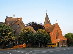 The municipal centre and St Peter's Church | |
 Flag  Coat of arms | |
 Location of Ohey in Namur Province | |
 Interactive map of Ohey | |
Ohey Location in Belgium | |
| Coordinates: 50°26′N 05°08′E / 50.433°N 5.133°E / 50.433; 5.133 | |
| Country | Belgium |
| Community | French Community |
| Region | Wallonia |
| Province | Namur |
| Arrondissement | Namur |
| Government | |
| • Mayor | Christophe Gilon |
| • Governing party | Plus d'Echo |
| Area | |
• Total | 56.68 km2 (21.88 sq mi) |
| Population (2018-01-01)1 | |
• Total | 5,090 |
| • Density | 89.8/km2 (233/sq mi) |
| Postal codes | 5350-5354 |
| NIS code | 92097 |
| Area codes | 085 |
| Website | www.ohey.be |
Ohey (French pronunciation: [ɔɛ]; Walloon: Ohè) is a municipality of Wallonia located in the province of Namur, Belgium.
On 1 January 2006 the municipality had 4,283 inhabitants. The total area is 56.62 km2 (21.86 sq mi), giving a population density of 76 inhabitants per square kilometre (200 inhabitants/mi2).
The municipality is composed of the following districts: Évelette, Goesnes, Haillot, Jallet, Ohey, Perwez.
Also located in Ohey are the villages of Bois-Dame-Agis, Ève, Filée, La Bouchaille, Libois, Résimont, Saint-Mort and Tahier.
References
References
- "Wettelijke Bevolking per gemeente op 1 januari 2018". Statbel. Retrieved 9 March 2019.
External links
External links
- Media related to Ohey at Wikimedia Commons
- Official website (in French)