Nollamara | |||||||||||||
|---|---|---|---|---|---|---|---|---|---|---|---|---|---|
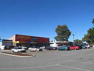 Nollamara Shopping Centre in 2012 | |||||||||||||
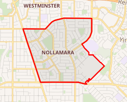 Interactive map of Nollamara | |||||||||||||
| Coordinates: 31°52′55″S 115°50′46″E / 31.882°S 115.846°E / -31.882; 115.846 | |||||||||||||
| Country | Australia | ||||||||||||
| State | Western Australia | ||||||||||||
| City | Perth | ||||||||||||
| LGA | |||||||||||||
| Location |
| ||||||||||||
| Government | |||||||||||||
| • State electorate | |||||||||||||
| • Federal division | |||||||||||||
| Area | |||||||||||||
• Total | 3.7 km2 (1.4 sq mi) | ||||||||||||
| Population | |||||||||||||
| • Total | 12,779 (SAL 2021)2 | ||||||||||||
| Postcode | 6061 | ||||||||||||
| |||||||||||||
Nollamara is a suburb of Perth, Western Australia. Its local government area is the City of Stirling.
The name "Nollamara" is a Noongar word for the flowering plant Macropidia, commonly known as the black kangaroo paw.3
The suburb is less than 10 km (6.2 mi) away from the Perth central business district and is approximately 11 km (6.8 mi) from Trigg beach. Previously known as a lower income area, Nollamara has gone through a period of gentrification over the past decade that continues on to this day. Older homes are being replaced with new townhomes and there has been a surge in young families and professionals populating the suburb. The area is characterized by extensive trees, parks and recreational facilities. The newly renovated Des Penman Reserve is a good example of this as it includes tennis, soccer, lawn-bowls, playground, shaded lunch areas and BBQ facilities. Parts of Nollamara are elevated, providing views of surrounding neighbourhoods.
Nollamara borders prominent areas such as Yokine and Dianella that are host to multimillion-dollar homes. A newly developed Flinders Street and Wanneroo Road provide easy access to Leederville, Subiaco, Northbridge and the Perth CBD.
Transport
The suburb is served by a number of Transperth bus routes operated by Swan Transit and Path Transit. The 371 (Mirrabooka-Yokine) covers Nollamara Shopping Centre and Flinders Street. The 384 (Mirrabooka-Perth) covers the Nollamara Shopping Centre and Wanneroo Road. The 970X and 970 (Mirrabooka-Perth) covers Flinders Street and inner portions of the suburb, the 389 (Wanneroo-Perth) and the 385/386 (Marangaroo-Perth) covers Wanneroo Road south to Perth, the 371 (Warwick-Mirrabooka) and 415 (Stirling-Mirrabooka) covers Ravenswood Drive in the north.
- 371 Mirrabooka Bus Station to Flinders Square – serves Ravenswood Drive, Flinders Street, Ilumba Road, Carcoola Street, Sylvia Street, Hillsborough Drive and Nollamara Avenue4
- 970X Landsdale to Perth Busport (limited stops) – serves Mirrabooka Avenue, Nollamara Avenue, Flinders Street and Mirrabooka Bus Station5
- 371 Warwick Station to Galleria Bus Station – serves Ravenswood Drive6
- 375 Mirrabooka Bus Station to Alexander Heights Shopping Centre – serves Ravenswood Drive7
- 384 Mirrabooka Bus Station to Perth Busport – serves Ravenswood Drive, Flinders Street, Ilumba Road, Carcoola Street, Sylvia Street, Hillsborough Drive, Nollamara Avenue and Wanneroo Road8
- 386X Perth Busport to Kingsway City (limited stops) – serves Wanneroo Road and Amelia Street9
- 386 Perth Busport to Kingsway City – serves Wanneroo Road and Amelia Street10
- 387 and 388 Perth Busport to Warwick Station – serve Wanneroo Road1112
- 389 Perth Busport to Wanneroo – serves Wanneroo Road13
- 415 Mirrabooka Bus Station to Stirling Station – serves Ravenswood Drive and Amelia Street14
- 970 Landsdale to Perth Busport (high frequency) – serves Mirrabooka Avenue, Nollamara Avenue and Flinders Street15
- 998 Fremantle Station to Fremantle Station (limited stops) – CircleRoute Clockwise, serves Morley Drive16
- 999 Fremantle Station to Fremantle Station (limited stops) – CircleRoute Anti-Clockwise, serves Morley Drive17
Facilities
- Quan The Am Nunnery, a Vietnamese Buddhist temple is located in the suburb.18
- Dhammaloka City centre, a Bhuddist temple in the tradition of Ajahn Chah, is located there as well.19
References
References
- Australian Bureau of Statistics (28 June 2022). "Nollamara (suburb and locality)". Australian Census 2021 QuickStats. Retrieved 28 June 2022.
- Australian Bureau of Statistics (28 June 2022). "Nollamara (suburb and locality)". Australian Census 2021 QuickStats. Retrieved 28 June 2022.
- "Mooro Nyoongar Katitjin Bidi" [Mooro People’s Knowledge Trail]. City of Stirling. Retrieved 28 April 2020.
- "Route 371". Bus Timetable 72 (PDF). Transperth. 30 October 2025 [effective from 30 November 2025].
- "Route 970X". Bus Timetable 211 (PDF). Transperth. 27 October 2025 [effective from 30 November 2025].
- "Route 975". Bus Timetable 205 (PDF). Transperth. 18 May 2026 [effective from 5 July 2026].
- "Route 375". Bus Timetable 74 (PDF). Transperth. 7 November 2025 [effective from 30 November 2025].
- "Route 384". Bus Timetable 72 (PDF). Transperth. 30 October 2025 [effective from 30 November 2025].
- "Route 386X". Bus Timetable 57 (PDF). Transperth. 30 October 2025 [effective from 30 November 2025].
- "Route 386". Bus Timetable 57 (PDF). Transperth. 30 October 2025 [effective from 30 November 2025].
- "Route 387". Bus Timetable 57 (PDF). Transperth. 30 October 2025 [effective from 30 November 2025].
- "Route 388". Bus Timetable 57 (PDF). Transperth. 30 October 2025 [effective from 30 November 2025].
- "Route 389". Bus Timetable 57 (PDF). Transperth. 30 October 2025 [effective from 30 November 2025].
- "Route 415". Bus Timetable 59 (PDF). Transperth. 5 November 2025 [effective from 30 November 2025].
- "Route 970". Bus Timetable 211 (PDF). Transperth. 27 October 2025 [effective from 30 November 2025].
- "Route 998". CircleRoute Timetable 200 (PDF) (CircleRoute). Transperth. 19 December 2025 [effective from 1 February 2026].
- "Route 999". CircleRoute Timetable 200 (PDF) (CircleRoute). Transperth. 19 December 2025 [effective from 1 February 2026].
- "Thành Viên Giáo Hội". The Unified Vietnamese Buddhist Congregation of Australia - New Zealand. Retrieved 14 July 2021.
- "Dhammaloka City Centre". Retrieved 9 November 2024.