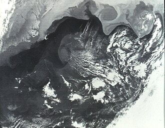
 Gulf Stream is seen as darker water extending to northeast from Cape Hatteras. This image was obtained from the Very High Resolution Radiometer (VHRR) on the NOAA-3 Satellite. | |
| Mission type | Weather |
|---|---|
| Operator | NOAA / NASA |
| COSPAR ID | 1973-086A1 |
| SATCAT no. | 6920 |
| Spacecraft properties | |
| Manufacturer | RCA Astrospace |
| Launch mass | 746 kilograms (1,645 lb) |
| Start of mission | |
| Launch date | November 6, 1973, 17:02 (1973-11-06UTC17:02Z) UTC |
| Rocket | Delta-300 |
| Launch site | Vandenberg SLC-2W |
| End of mission | |
| Deactivated | August 1976 (1976-09) |
| Orbital parameters | |
| Reference system | Geocentric |
| Regime | Low Earth Sun-synchronous |
| Perigee altitude | 1,500 kilometers (930 mi) |
| Apogee altitude | 1,509 kilometers (938 mi) |
| Inclination | 102.1° |
| Period | 116.11 minutes |
| Epoch | November 6, 1973 |
ITOS | |
NOAA-3, also known as ITOS-F was a weather satellite operated by the National Oceanic and Atmospheric Administration (NOAA).2 It was part of a series of satellites called ITOS, or improved TIROS.3 It was deactivated by NOAA in August 1976.
References
References
- "NASA/NSSDC NOAA-3 spacecraft details". Retrieved June 7, 2018.
- "WMO OSCAR | Satellite: NOAA-3". space.oscar.wmo.int. Retrieved March 20, 2024.
- Wade, Mark. "ITOS". Encyclopedia Astronautica. Archived from the original on June 21, 2002. Retrieved June 6, 2018.