| Nether Denton | |
|---|---|
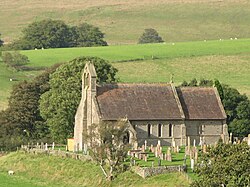 St Cuthbert's Church, Nether Denton | |
Nether Denton Location within Cumbria | |
| Population | 408 (2021 (including Upper Denton)) |
| OS grid reference | NY602631 |
| Civil parish |
|
| Unitary authority | |
| Ceremonial county | |
| Region | |
| Country | England |
| Sovereign state | United Kingdom |
| Post town | BRAMPTON |
| Postcode district | CA8 |
| Dialling code | 016977 |
| Police | Cumbria |
| Fire | Cumbria |
| Ambulance | North West |
| UK Parliament | |
| Website | www |
Nether Denton is a scattered settlement and civil parish in rural Cumbria, England, situated about 12 miles (19 km) north-east of Carlisle, by the A69 road. The population of the parish taken at the 2021 census was 408.1 Nether Denton is a couple of miles south-west of the village of Upper Denton. The parish contains the village of Low Row.
St Cuthbert's Church at Nether Denton is built at the site of a Roman fort, around 0.5 miles (0.80 km) south of Hadrian's Wall on the Stanegate road. The present building dates from 1868 to 1870, but there has been a church on the site since the 12th century.2 Denton Hall, now a farmhouse, comprises a 14th-century pele tower, gabled and reduced in height, adjoining a house of 1829. The walls of the tower are 2m thick.3
References
References
- "Nether Denton Parish in North West England". City Population. Retrieved 30 April 2026.
- Church of St. Cuthbert at British Listed Buildings Online
- Denton Hall at Pastscape
External links
External links
- Cumbria County History Trust: Nether Denton (nb: provisional research only – see Talk page)