 | |
 | |
| Location | Negril Point Westmoreland Jamaica4 |
|---|---|
| Coordinates | 18°14′54″N 78°21′38″W / 18.2484318°N 78.3605111°W / 18.2484318; -78.36051111 |
| Tower | |
| Constructed | 18942 |
| Foundation | a 14 feet (4.3 m) deep tank of water for balance and security during earthquakes2 |
| Construction | reinforced concrete tower4 |
| Automated | yes3 |
| Height | 27 metres (89 ft)3 |
| Shape | tapered cylindrical tower with balcony and lantern |
| Markings | white tower and lantern2 |
| Power source | solar power  |
| Heritage | national monument |
| Light | |
| Focal height | 31 metres (102 ft)4 |
| Range | 15 nmi (28 km; 17 mi) |
| Characteristic | One flash every 2 s, alternating red and white4 |

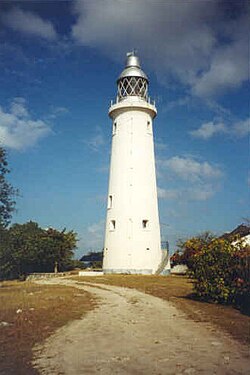
Negril Lighthouse was built in 1894 1.5 miles (2.4 km) south south east of the westernmost tip of the island of Jamaica by the French company Barber & Bernard.2 It is one of the earliest concrete lighthouses.4

Its foundation is a tank 14 feet (4.3 m) deep, which is kept filled with water to keep the 20-metre (66 ft)2 (27 metres (89 ft) according to Rowlett)4 reinforced concrete tower balanced and secured in the event of an earthquake.2 The tower is topped with a lantern and gallery.4
An automatic white light 30 m (100 feet) above sea level flashes every two seconds.4 The light was operated by gas initially, switching to acetylene in 1956 and solar energy in 1985.23
Several adjacent one-story frame keeper's houses are staffed.4
The site is a well-known attraction of the Negril area.4
It is maintained by the Port Authority of Jamaica, an agency of the Ministry of Transport and Works.4
References
References
- UK Directorate of Overseas Surveys 1:50,000 map of Jamaica (12 sheets), 1958-1973.
- Negril Point Lighthouse Archived 2011-06-29 at the Wayback Machine, Jamaica National Heritage Trust, 2005.
- Negril Point Lighthouse, Frans Eijgenraam, 2000.
- Rowlett, Russ (2008-10-20). "Lighthouses of Jamaica". The Lighthouse Directory. University of North Carolina at Chapel Hill.