Myslava | |
|---|---|
Borough | |
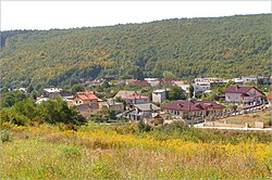 Panorama of Myslava (August 2012) | |
 Flag 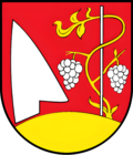 Coat of arms | |
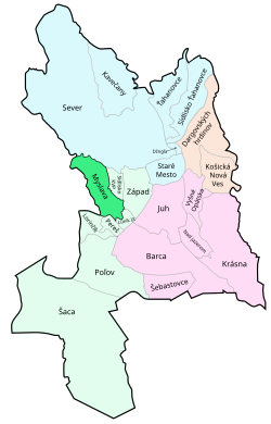 Location within Košice | |
| Country |  Slovakia Slovakia |
| Region | Košice |
| District | Košice II |
| Village | 1382 (first known record) |
| Area | |
• Total | 6.99 km2 (2.70 sq mi) |
| Elevation | 252 m (827 ft) |
| Population | |
• Total | 2,687 |
| Time zone | UTC+1 (CET) |
| • Summer (DST) | UTC+2 (CEST) |
| Postal code | 040 16 |
| Area code | +421-55 |
| Vehicle registration plate (until 2022) | KE |
| Website | www.myslava.eu |
Myslava (Hungarian: Miszlóka, German: Deutschendorf) is a borough (city ward) of the city of Košice, Slovakia. Located in the Košice II district, it lies at an altitude of roughly 252 metres (827 ft) above sea level, and is home to over 2,200 people. It retains much of its rural character.
History
The first written record of Myslava dates back to 1382.
It was an independent village municipality until it was connected to Košice.
Statistics
- Area: 7.01 square kilometres (2.71 sq mi)
- Population: 2,257 (December 2017)
- Density of population: 320/km2 (December 2017)
- District: Košice II
- Mayor: Iveta Šimková (as of 2018 elections)
Geography
The municipality lies at an altitude of 252 metres (827 ft)3 and covers an area of 6.99 km2 (2.70 sq mi) (2025).4
Population
| Year | 1995 | 2005 | 2015 | 2025 |
|---|---|---|---|---|
| Count | 0 | 1836 | 2120 | 2687 |
| Difference | – | +15.46% | +26.74% |
| Year | 2024 | 2025 |
|---|---|---|
| Count | 2681 | 2687 |
| Difference | +0.22% |
It has a population of 2687 people (31 December 2025).6
Ethnicity
| Ethnicity | Number | Fraction |
|---|---|---|
| Slovak | 2369 | 93.08% |
| Not found out | 128 | 5.02% |
| Czech | 31 | 1.21% |
| Rusyn | 31 | 1.21% |
| Hungarian | 30 | 1.17% |
| Total | 2545 |
In year 2021 was 2545 people by ethnicity 2369 as Slovak, 128 as Not found out, 31 as Czech, 31 as Rusyn, 30 as Hungarian, 10 as Other, 6 as Romani, 5 as Ukrainian, 5 as Russian, 4 as German, 3 as Vietnamese, 3 as Polish, 2 as Romanian, 1 as Jewish, 1 as Serbian, 1 as Bulgarian, 1 as English and 1 as Albanian.
Note on population: The difference values of population numbers in the table "Population statistic" and in the sections "Ethnicity" & "Religion" is caused by the use of various statistical methods.
Religion
| Religion | Number | Fraction |
|---|---|---|
| Roman Catholic Church | 1554 | 61.06% |
| None | 569 | 22.36% |
| Greek Catholic Church | 132 | 5.19% |
| Not found out | 130 | 5.11% |
| Evangelical Church | 54 | 2.12% |
| Eastern Orthodox Church | 27 | 1.06% |
| Total | 2545 |
In year 2021 was 2545 people by religion 1554 from Roman Catholic Church, 569 from None, 132 from Greek Catholic Church, 130 from Not found out, 54 from Evangelical Church, 27 from Eastern Orthodox Church, 21 from Calvinist Church, 12 from Baptists Church, 10 from Ad hoc movements, 7 from Jehovah's Witnesses, 7 from Other, 4 from Other and not ascertained christian church, 4 from Christian Congregations in Slovakia, 3 from Seventh-day Adventist Church, 3 from Apostolic Church, 2 from Paganism and natural spirituality, 2 from Islam, 2 from Buddhism, 1 from Jewish community and 1 from Bahá'i Community.
Gallery
-
 Church of St Bartholomew in the Myslava borough (May 2012)
 -
 Church of St Bartholomew in the Myslava borough (May 2015)
 -
 Church of St Bartholomew interior
 -
 Church of St Bartholomew interior (altar)
References
References
- "Hustota obyvateľstva - obce [om7014rr_obc=AREAS_SK, v_om7014rr_ukaz=Rozloha (Štvorcový meter)]". Statistical Office of the Slovak Republic. 2026-03-31. Retrieved 2026-03-31.
- "Počet obyvateľov podľa pohlavia - obce (ročne) [om7101rr_obce=AREAS_SK]". Statistical Office of the Slovak Republic. 2026-03-31. Retrieved 2026-03-31.
- "Základná charakteristika". www.statistics.sk (in Slovak). Statistical Office of the Slovak Republic. 2015-04-17. Retrieved 2022-03-31.
- "Hustota obyvateľstva - obce [om7014rr_obc=AREAS_SK, v_om7014rr_ukaz=Rozloha (Štvorcový meter)]". Statistical Office of the Slovak Republic. 2026-03-31. Retrieved 2026-03-31.
- "Počet obyvateľov podľa pohlavia - obce (ročne) [om7101rr_obce=AREAS_SK]". Statistical Office of the Slovak Republic. 2026-03-31. Retrieved 2026-03-31.
- "Počet obyvateľov podľa pohlavia - obce (ročne) [om7101rr_obce=AREAS_SK]". Statistical Office of the Slovak Republic. 2026-03-31. Retrieved 2026-03-31.
- "Population - Basic results". www.scitanie.sk. Statistical Office of the Slovak republic. Retrieved 2025-11-03.
- "Population - Basic results". www.scitanie.sk. Statistical Office of the Slovak republic. Retrieved 2025-11-03.
- "Population - Basic results". www.scitanie.sk. Statistical Office of the Slovak republic. Retrieved 2025-11-03.