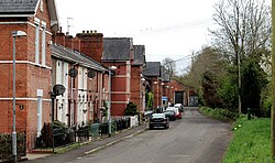
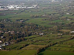
Muckamore (Irish: Maigh Chomair) is a townland and village on the outskirts of Antrim in County Antrim, Northern Ireland.1 It is located in the civil parish of the Grange of Muckamore in the barony of Massereene Lower.2
It is the location of Muckamore Abbey Hospital and the disused Muckamore railway station. Muckamore Cricket Club is named after the village. Muckamore Forest is nearby.3
History
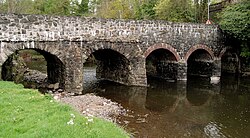
Muckamore Priory was an Augustinian priory which dates back to at least 1283, and was itself built on the site of an earlier church building.4 Only buried ruins of the original priory remain, which were examined during excavations in 1973.5 A further survey was made in 2011.6
A document in the Ordnance Survey Memoirs of Ireland hypothesizes that the name may have derived from the Irish muck airi mor, for "great field of adoration".6
In 1861, the townland of Muckamore was described as having ten subdivisions, known as "towns".7 As of 1831, it had a recorded population of 1,479.8
References
References
- "Muckamore Townland, Co. Antrim". www.townlands.ie. Retrieved 2026-06-18.
- "Maigh Chomair/Muckamore". logainm.ie. Retrieved 18 June 2026.
- "Muckamore Forest, including Rea's Wood, Antrim town | nidirect". www.nidirect.gov.uk. 2015-11-05. Retrieved 2026-06-18.
- "Muckamore Priory". Department for Communities. Retrieved 19 June 2026.
- "Muckamore Abbey, Muckamore Priory". Northern Ireland Sites and Monuments Record. Retrieved 2026-06-19.
- "Muckamore Abbey, County Antrim: geophysical report" (PDF). Queen's University, Belfast. p. 23. Archived from the original (PDF) on 2024-07-12. Retrieved 15 July 2025.
- Reeves, W. (1857). "On the Townland Distribution of Ireland". Proceedings of the Royal Irish Academy (1836-1869). 7: 473–490. ISSN 0302-7597.
- "1831 Census of Ireland, Abstracts of Answers and Returns Made under the Population Acts, 55 Geo. III -- Chap. 120. 3 Geo. IV. -- Chap. 5. 2 Geo. IV. -- Chap. 30. 1 Will. IV. -- Chap. 19.: Enumeration 1831". visionofireland.org. Retrieved 18 June 2026.
54°41′56″N 6°11′00″W / 54.6990°N 6.1833°W / 54.6990; -6.1833