| Mount William Booth | |
|---|---|
 | |
| Highest point | |
| Elevation | 2,728 m (8,950 ft)12 |
| Prominence | 795 m (2,608 ft)3 |
| Listing | Mountains of Alberta |
| Coordinates | 52°05′22″N 116°19′14″W / 52.0894444°N 116.3205556°W / 52.0894444; -116.32055564 |
| Geography | |
Mount William Booth Location within Alberta Show map of AlbertaMount William Booth Location within Canada Show map of Canada | |
Country | Canada |
Province | Alberta |
| Parent range | Ram Range |
| Topo map | NTS 83C1 Whiterabbit Creek4 |
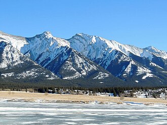
Mount William Booth was named in 1965 after William Booth, the founder of the Salvation Army.1 It is part of the Ram Range in Alberta, Canada, and situated near the southern end of Abraham Lake. It is located in the North Saskatchewan River valley of the Canadian Rockies, and can be seen from the David Thompson Highway east of Saskatchewan Crossing.
Climate
Based on the Köppen climate classification, Mount William Booth is located in a subarctic climate with cold, snowy winters, and mild summers.5 Temperatures can drop below -20 °C with wind chill factors below -30 °C.
Gallery
-
 Mount William Booth
References
References
- "Mount William Booth". cdnrockiesdatabases.ca. Retrieved 2024-01-08.
- "Topographic map of Mount William Booth". opentopomap.org. Retrieved 2024-01-08.
- "Mount William Booth". Bivouac.com. Retrieved 2019-02-28.
- "Mount William Booth". Geographical Names Data Base. Natural Resources Canada. Retrieved 2024-01-08.
- Peel, M. C.; Finlayson, B. L.; McMahon, T. A. (2007). "Updated world map of the Köppen-Geiger climate classification" (PDF). Hydrology and Earth System Sciences. 11 (5): 1633–1644. Bibcode:2007HESS...11.1633P. doi:10.5194/hess-11-1633-2007. Archived (PDF) from the original on 2019-12-02. Retrieved 2025-11-07.