| Mount Warspite | |
|---|---|
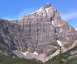 Mount Warspite, northeast face | |
| Highest point | |
| Elevation | 2,850 m (9,350 ft)12a |
| Prominence | 240 m (790 ft)3 |
| Parent peak | Mount Black Prince (2939 m)3 |
| Listing | Mountains of Alberta |
| Coordinates | 50°40′52″N 115°12′59″W / 50.68111°N 115.21639°W / 50.68111; -115.216394 |
| Geography | |
Mount Warspite Location of Mount Warspite in Alberta Show map of AlbertaMount Warspite Mount Warspite (Canada) Show map of Canada | |
Country | Canada |
Province | Alberta |
Protected area | Peter Lougheed Provincial Park52 |
| Parent range | |
| Topo map | NTS 82J11 Kananaskis Lakes4 |
| Climbing | |
| Easiest route | Difficult Scramble1 |
Mount Warspite is a 2,850-metre (9,350-foot) mountain summit located in Peter Lougheed Provincial Park in the Canadian Rockies of Alberta, Canada. The peak is visible from Smith-Dorrien Road (742), and Alberta Highway 40 in the Kananaskis Lakes area. Mount Warspite's nearest higher peak is Mount Black Prince, located 2.4 km (1.5 mi) to the northwest.3
Like many of the mountains in Kananaskis Country, Mount Warspite is named after figures and ships involved in the 1916 Battle of Jutland, a significant naval engagement of the First World War. Mount Warspite was named in 1917 for the British battleship HMS Warspite, one of the most decorated and revered ships in Royal Navy history that fought during the Battle of Jutland and survived to also serve in World War II.67 The mountain's name was officially adopted in 1922 by the Geographical Names Board of Canada.4
Geology
Mount Warspite is composed of sedimentary rock laid down during the Precambrian to Jurassic periods. Formed in shallow seas, this sedimentary rock was pushed east and over the top of younger rock during the Laramide orogeny.8
Climate
Based on the Köppen climate classification, Mount Warspite is located in a subarctic climate zone with cold, snowy winters, and mild summers.9 Temperatures can drop below −20 °C (−4 °F) with wind chill factors below −30 °C (−22 °F). Precipitation runoff from the mountain drains into tributaries of the Kananaskis River, thence into the Bow River.
References
References
- Kane, Alan (1999). "Mount Warspite". Scrambles in the Canadian Rockies. Calgary: Rocky Mountain Books. pp. 160–161. ISBN 0-921102-67-4.
- Kananaskis Lakes (Map). 1:50,000. Cochrane, AB: Gem Trek Publishing. 2024 [1998]. § C3. ISBN 1-895526-24-8. Retrieved 2025-05-01.
- "Mount Warspite". Bivouac.com. Retrieved 2018-12-07.
- "Mount Warspite". Geographical Names Data Base. Natural Resources Canada. Retrieved 2019-07-15.
- NTS map sheet 82J11 Kananaskis Lakes
- "Battle of Jutland". Alberta Historic Places. Retrieved 2025-05-01.
- Place-names of Alberta. Ottawa: Geographic Board of Canada. 1928. p. 131. Retrieved 2025-05-01.
- Gadd, Ben (2008), Geology of the Rocky Mountains and Columbias
- Peel, M. C.; Finlayson, B. L.; McMahon, T. A. (2007). "Updated world map of the Köppen−Geiger climate classification". Hydrol. Earth Syst. Sci. 11: 1633–1644. ISSN 1027-5606.
- Notes
- Another source states 2860 m.3
External links
External links
- Mt. Warspite photo: Flickr
- Mt. Warspite pano: Flickr
- Mount Warspite weather: Mountain Forecast