| Mount St. Bride | |
|---|---|
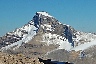 Mount St Bride seen from Fossil Mountain | |
| Highest point | |
| Elevation | 3,315 m (10,876 ft)12 |
| Prominence | 1,207 m (3,960 ft)3 |
| Parent peak | Mount Hector (3394 m)3 |
| Listing | Mountains of Alberta |
| Coordinates | 51°30′28″N 115°57′19″W / 51.50778°N 115.95528°W / 51.50778; -115.955284 |
| Geography | |
Mount St. Bride Location in Alberta Show map of AlbertaMount St. Bride Location in Canada Show map of Canada | |
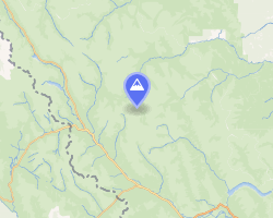 | |
| Interactive map of Mount St. Bride | |
Country | Canada |
Province | Alberta |
Protected area | Banff National Park |
| Parent range | |
| Topo map | NTS 82O12 Barrier Mountain4 |
| Geology | |
| Rock age | Cambrian |
| Rock type | Sedimentary rock |
| Climbing | |
| First ascent | 1910 J.W.A. Hickson, Edward Feuz Sr., Edward Feuz Jr.1 |
Mount St. Bride is a prominent 3,315-metre (10,876 ft) mountain summit located in Banff National Park, in the Rocky Mountains of Alberta. It is the highest point in the Sawback Range.5 Its nearest higher peak is Cataract Peak, located 18.8 km (11.7 mi) to the northwest.3 Mount St. Bride is situated 2.0 km (1.2 mi) to the south of Mount Douglas, near the headwaters of the Red Deer River.
History
Mount St. Bride was named in 1898 in honor of Saint Bride, the patron saint of the Douglas family.16
The first ascent of the mountain was achieved in 1910 by J. W. A. Hickson accompanied by guides, Edward Feuz Sr. and Edward Feuz Jr.1
The mountain's name was officially adopted in 1956 when approved by the Geographical Names Board of Canada.4
Geology
Like other mountains in Banff Park, Mount St. Bride is composed of sedimentary rock that was deposited during the Precambrian to Jurassic periods.7 Formed in shallow seas, this sedimentary rock was pushed eastward and over the top of younger rock during the Laramide orogeny.8
Climate
Based on the Köppen climate classification, Mount St. Bride is located in a subarctic climate zone characterized by cold, snowy winters, and mild summers.9 Winter temperatures can drop below −20 °C, with wind chill factors reaching below −30 °C.
Gallery
-
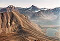 Mount St. Bride in the distance
 -
 Mount St. Bride centered (1922)
References
References
- "Mount St. Bride". cdnrockiesdatabases.ca. Retrieved 2019-09-21.
- "Topographic map of Mount St. Bride". opentopomap.org. Retrieved 2023-07-24.
- "Mount Saint Bride". Bivouac.com. Retrieved 2019-02-16.
- "Mount St. Bride". Geographical Names Data Base. Natural Resources Canada. Retrieved 2019-02-16.
- "Mount Saint Bride". Peakbagger.com. Retrieved 2019-09-21.
- Place-names of Alberta. Ottawa: Geographic Board of Canada. 1928. p. 112.
- Belyea, Helen R. (1960). The Story of the Mountains in Banff National Park (PDF). parkscanadahistory.com (Report). Ottawa: Geological Survey of Canada. Archived (PDF) from the original on 2015-10-02. Retrieved 2019-09-13.
- Gadd, Ben (2008). Geology of the Rocky Mountains and Columbias.
- Peel, M. C.; Finlayson, B. L.; McMahon, T. A. (2007). "Updated world map of the Köppen−Geiger climate classification". Hydrol. Earth Syst. Sci. 11 (5): 1633–1644. Bibcode:2007HESS...11.1633P. doi:10.5194/hess-11-1633-2007. ISSN 1027-5606.
External links
External links
- Weather forecast: Mount St. Bride
- Parks Canada web site: Banff National Park