| Mount Spring-Rice | |
|---|---|
 | |
| Highest point | |
| Elevation | 3,275 m (10,745 ft)12 |
| Prominence | 426 m (1,398 ft)3 |
| Parent peak | Mount Alexandra (3401 m)3 |
| Listing | |
| Coordinates | 52°01′00″N 117°14′08″W / 52.01667°N 117.23556°W / 52.01667; -117.235564 |
| Geography | |
Mount Spring-Rice Location within Alberta Show map of AlbertaMount Spring-Rice Location within British Columbia Show map of British ColumbiaMount Spring-Rice Location within Canada Show map of Canada | |
Country | Canada |
Provinces | Alberta and British Columbia |
Protected area | Banff National Park |
| Parent range | Park Ranges |
| Topo map | NTS 83C3 Columbia Icefield4 |
| Climbing | |
| First ascent | 1923 J. W. A. Hickson, E. Feuz13 |
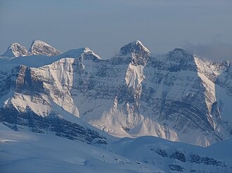
Mount Spring-Rice is located on the border of Alberta and British Columbia, south of Thompson Pass.5 It was named in 1918 by Arthur O. Wheeler after the British diplomat, Sir Cecil Spring Rice.13
See also
See also
References
References
- "Mount Spring-Rice". cdnrockiesdatabases.ca. Retrieved 2021-11-11.
- "Topographic map of Mount Spring-Rice". opentopomap.org. Retrieved 2021-11-11.
- "Mount Spring-Rice". Bivouac.com. Retrieved 2021-11-11.
- "Mount Spring-Rice (Alberta)". Geographical Names Data Base. Natural Resources Canada. Retrieved 2021-11-09.
- "Mount Spring-Rice". BC Geographical Names. Government of British Columbia – B.C. Geographical Names Office (BCGNO). Retrieved 2021-11-11.