| Mount Lamlam | |
|---|---|
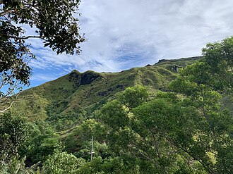 Mount Lamlam | |
| Highest point | |
| Elevation | 1,332 ft (406 m)1 |
| Prominence | 1,332 ft (406 m) |
| Coordinates | 13°20′19″N 144°39′46″E / 13.33861°N 144.66278°E / 13.33861; 144.662782 |
| Geography | |
Mount Lamlam Guam | |
| Location | Near Agat, Guam, Micronesia, U.S. territory |
| Topo map | USGS Agat |
| Climbing | |
| Easiest route | |
| Designated | 1972 |
Mount Lamlam (meaning lightning in Chamoru) is a peak on the United States island of Guam. It is located near the village of Agat (5 km or 3 mi3 north), in the south-west of the island.
Rising to 406 meters (1,332 ft) above sea level, the distance from the peak to the bottom of the nearby Mariana Trench is said to be the greatest change in elevation on Earth over such a short distance.4
References
References
- "Highest Mountain Peaks in Guam". MountainZone.com
- "Mount Lamlam". Geographic Names Information System. United States Geological Survey, United States Department of the Interior.
- "Mount Lamlam". MountainZone.com
- One internet site Geography of Guam Archived 1996-10-27 at the Wayback Machine claims the difference is 37,820 feet (11,530 m). However, this is measured relative to the Challenger Deep, not the part of the trench adjacent to Guam.
- Bendure, G. & Friary, N. (1988) Micronesia:A travel survival kit. South Yarra, VIC: Lonely Planet.