| Mount Hurd | |
|---|---|
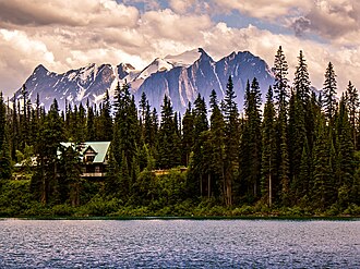 Mt. Vaux centered with Mt. Hurd furthest right in this view from Emerald Lake | |
| Highest point | |
| Elevation | 3,000 m (9,800 ft)12 |
| Prominence | 355 m (1,165 ft)12 |
| Parent peak | Mount Vaux1 |
| Listing | Mountains of British Columbia |
| Coordinates | 51°17′06″N 116°32′11″W / 51.28500°N 116.53639°W / 51.28500; -116.536393 |
| Geography | |
Mount Hurd Location in British Columbia Show map of British ColumbiaMount Hurd Location in Canada Show map of Canada | |
Country | Canada |
Province | British Columbia |
District | Kootenay Land District |
Protected area | Yoho National Park |
| Parent range | |
| Topo map | NTS 82N7 Golden3 |
| Climbing | |
| First ascent | 1948 Mr. and Mrs. E. Cromwell4 |
Mount Hurd is a mountain in the Ottertail Range of the Canadian Rockies in British Columbia, Canada. It was named after Major Marshall Farnam Hurd (1823-1903) a Canadian Pacific Railway engineer and explorer.5 It was featured on a 1928 Canada Post 10¢ stamp based on a painting by Frederic Marlett Bell-Smith.
Climate
Based on the Köppen climate classification, Mount Hurd is located in a subarctic climate with cold, snowy winters, and mild summers.6 Temperatures can drop below −20 °C with wind chill factors below −30 °C. Precipitation runoff from Mount Hurd drains into tributaries of the Kicking Horse River which is a tributary of the Columbia River.
References
References
- "Mount Hurd, British Columbia". Peakbagger.com. Retrieved 2019-12-12.
- "Mount Hurd". Bivouac.com. Retrieved 2021-07-27.
- "Mount Hurd". Geographical Names Data Base. Natural Resources Canada. Retrieved 2021-07-27.
- "Mount Hurd". cdnrockiesdatabases.ca. Retrieved 2025-04-07.
- "Mount Hurd". BC Geographical Names. Government of British Columbia – B.C. Geographical Names Office (BCGNO). Retrieved 2021-07-27.
- Peel, M. C.; Finlayson, B. L.; McMahon, T. A. (2007). "Updated world map of the Köppen-Geiger climate classification" (PDF). Hydrology and Earth System Sciences. 11 (5): 1633–1644. Bibcode:2007HESS...11.1633P. doi:10.5194/hess-11-1633-2007. Archived (PDF) from the original on 2019-12-02. Retrieved 2025-11-07.