| Mount Gower | |
|---|---|
| Big Hill1 | |
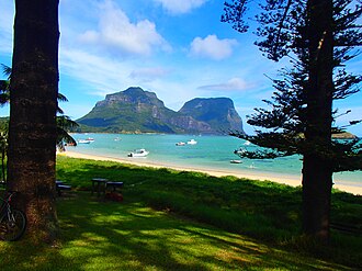 Lord Howe Island's two southern mountains in the background, Mount Lidgbird (left) and Mount Gower (right) | |
| Highest point | |
| Elevation | 875 m (2,871 ft) |
| Prominence | 875 m (2,871 ft) |
| Coordinates | 31°35′25″S 159°04′20″E / 31.59028°S 159.07222°E / -31.59028; 159.072221 |
| Geography | |
Mount Gower | |
| Location | Lord Howe Island, New South Wales, Australia |
| Geology | |
| Volcanic | |
Mount Gower (also known as Big Hill),1 is the highest mountain on Australia's subtropical Lord Howe Island in the Tasman Sea. With a height of 875 metres (2,871 ft) above sea level, and a relatively flat 27-hectare (67-acre) summit plateau, it stands at the southern end of Lord Howe, just south of the island's second highest peak, the 777-metre (2,549 ft) high Mount Lidgbird, from which it is separated by the saddle at the head of Erskine Valley.
Ascending Gower entails a popular, guided, strenuous 8-hour return hike, though no special climbing skills are needed. The mountain is covered with rainforest, including cloud forest at the summit, containing many of the island's endemic plants.23
References
References
- "Mount Gower". Geographical Names Register (GNR) of NSW. Geographical Names Board of New South Wales. Retrieved 25 May 2015.
- "Mt Gower". Lord Howe Island Tourism Association. Retrieved 28 January 2014.
- Hutton, Ian (1998). The Australian Geographic Book of Lord Howe Island. Sydney: Australian Geographic. pp. 59–63. ISBN 1-876276-27-4.