| Mount Chevalier | |
|---|---|
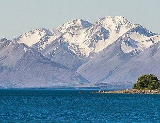 South aspect, centred (Mount Ross to right) | |
| Highest point | |
| Elevation | 2,404 m (7,887 ft)12 |
| Prominence | 494 m (1,621 ft)2 |
| Isolation | 5.89 km (3.66 mi)2 |
| Listing | New Zealand #103 |
| Coordinates | 43°34′09″S 170°39′05″E / 43.569078°S 170.651389°E / -43.569078; 170.6513893 |
| Naming | |
| Etymology | Nicholas Chevalier |
| Geography | |
Mount Chevalier Location in New Zealand | |
 | |
| Interactive map of Mount Chevalier | |
| Location | South Island |
Country | New Zealand |
Region | Canterbury |
Protected area | Te Kahui Kaupeka Conservation Park |
| Parent range | Southern Alps Two Thumb Range4 |
| Topo map | NZMS260 I364 |
| Climbing | |
| First ascent | 1941 |
Mount Chevalier is a 2,404-metre-elevation (7,887-foot) mountain in Canterbury, New Zealand.
Description
Mount Chevalier is part of the Two Thumb Range which is a subrange of the Southern Alps. It is located 185 kilometres (115 mi) west of the city of Christchurch in the Canterbury Region of the South Island.4 Precipitation runoff from the mountain drains west into the Macaulay River and east into North East Gorge Stream, which is a tributary of the Macaulay. Topographic relief is significant as the summit rises 1,400 metres (4,593 feet) above the Macaulay Valley in three kilometres. The nearest higher neighbour is Achilles Peak, six kilometres to the east.2 The mountain's toponym was applied by Julius von Haast to honour Nicholas Chevalier (1828–1902), a Russian-born artist who visited New Zealand in 1865.4 The first ascent of the summit was made in December 1941 by Bob Clark-Hall and J.L. (Pat) Clark-Hall via the South Face.3
Climate
Based on the Köppen climate classification, Mount Chevalier is located in a marine west coast (Cfb) climate zone.5 Prevailing westerly winds blow moist air from the Tasman Sea onto the mountains, where the air is forced upwards by the mountains (orographic lift), causing moisture to drop in the form of rain or snow. The months of December through February offer the most favourable weather for viewing or climbing this peak.6
Gallery
-
 Mount Chevalier centred and Mount Ross to right, viewed from Lake Tekapo.
 -
 Mount Ross to left, with Mount Chevalier behind (upper left corner).
South aspect, from south end of Lake Tekapo. -
 Mount Chevalier and Mount Ross centred, viewed from Lake Tekapo.
 -
 Nicholas Chevalier
References
References
- Mount Chevalier, Canterbury, NZTopoMap, Retrieved 4 February 2025.
- "Mount Chevalier, New Zealand". Peakbagger.com. Retrieved 4 February 2025.
- Mt Chevalier, New Zealand Alpine Club, Climbnz.org, Retrieved 4 February 2025.
- Mount Chevalier, New Zealand Gazetteer, Retrieved 4 February 2025.
- Christchurch Climate (New Zealand), climate-data.org, Retrieved 4 February 2025.
- The Best Time to Visit the South Island, nzpocketguide.com, Retrieved 4 February 2025.