| Mount Allyn | |
|---|---|
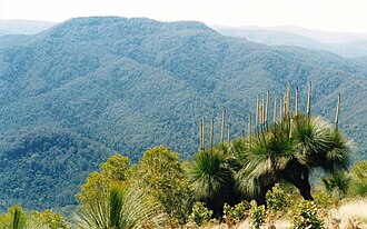 Mount Allyn & Grass Trees, photographed from Mount Cabrebald | |
| Highest point | |
| Elevation | 1,125 m (3,691 ft) |
| Listing | List of mountains in Australia |
| Coordinates | 32°7.48′S 151°25.74′E / 32.12467°S 151.42900°E / -32.12467; 151.42900 |
| Geography | |
Mount Allyn Location in New South Wales | |
| Location | Chichester State Forest, Upper Hunter region, New South Wales, Australia |
Country | Australia |
| Parent range | Allyn Range |
| Geology | |
| Rock age | Eocene |
Mount Allyn is a mountain1 with an elevation of 1,125 metres (3,691 ft) AHD that is part of the Allyn Range, located within the Chichester State Forest, in the Upper Hunter region of New South Wales, Australia. Mount Allyn is located about 8 kilometres (5.0 mi) south southwest of Careys Peak1 and about 50 kilometres (31 mi) northeast of Muswellbrook.
Snow often falls in winter. Much of the mountain is covered in Antarctic beech cool temperate rainforest.2
There is dirt-road access to the peak.
References
References
- "Mount Allyn". Geographical Names Register (GNR) of NSW. Geographical Names Board of New South Wales. Retrieved 9 October 2013.
- "Nothofagus moorei | Antarctic Beech". Occurrence Record. Atlas of Living Australia. Retrieved 31 May 2012.