Morowali Regency
Kabupaten Morowali | |
|---|---|
 Morowali Industrial Park | |
 Coat of arms | |
| Motto: Tepe Asa Maroso (Pamona) (United We Are Firm) | |
 Location within Central Sulawesi | |
| Coordinates: 2°49′07″S 121°51′39″E / 2.818536°S 121.860786°E / -2.818536; 121.860786 | |
| Country | Indonesia |
| Province | Central Sulawesi |
| Capital | Bungku |
| Government | |
| • Regent | Iksan Baharudin Abdul Rauf |
| • Vice Regent | Iriane Iliyas |
| Area (as reduced by the separation of North Morowali) | |
• Total | 5,472 km2 (2,113 sq mi) |
| Population (mid 2025 estimate)1 | |
• Total | 203,860 |
| • Density | 37.26/km2 (96.49/sq mi) |
| Time zone | UTC+8 (ICST) |
| Area code | (+62) 464/465 |
| Website | morowalikab |
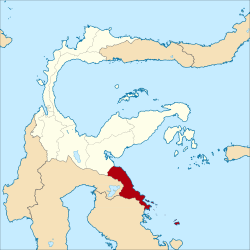
Morowali Regency is a regency of Central Sulawesi Province of Indonesia. It covers a land area of 5,472 km2. The districts currently within the regency had a combined population of 102,228 at the 2010 Census;2 the regency population at the 2020 Census was 161,727;3 and with rapid growth in the regency's population in recent years the official estimate as of mid 2025 was 203,860 (comprising 107,363 males and 93,559 females).1 The administrative centre is at the town of Bungku (in Bungku Tengah District), which comprises six kelurahan and a number of desa. The Regency includes the far-flung Menui Islands (Kepulauan Menui), lying to the southeast of the rest of the province.
History
Before Dutch rule, the region comprising what is today Morowali was the territory of the Kingdom of Bungku. After Dutch annexation, it was administered as the landschap of Boengkoe.4 On 4 October 1999, Morowali Regency was created out of a portion of Poso Regency.5 At that time it was composed of the southeastern fourteen districts from the Poso Regency.
On 12 April 2013 this Morowali Regency was in turn divided into two Regencies; the seven northernmost districts were split off to form a new North Morowali Regency (Morowali Utara) covering nearly two-thirds of the area of the then Morowali Regency, while the seven southernmost districts were retained as the residual Morowali Regency, although two additional districts were created by the division of existing ones.
Economy
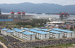
Morowali Regency contains rich deposits of high-quality nickel, a vital material needed to manufacture lithium batteries. Starting in the 2010s and into the 2020s, the thriving nickel industry in Morowali has resulted in a large increase in the region's GDP (300% increase between 2013 and 2019),6 but the expansion of the extraction industry has also caused environmental degradation.6 From 2014 to 2020, over US$6.5 billion in foreign direct investment has flowed into the construction of nickel smelters and other downstream processing activities in Morowali Regency. Morowali is the site of an industrial park, the Morowali Industrial Park, specifically earmarked for refining activities. In Morowali, GDP more than tripled in just six years from Rp 6.9 trillion (US$480 million) in 2013 to Rp 24.3 trillion (US$1.7 billion) in 2019, almost all of it driven by investment in downstream nickel processing. As of 2021, the largest foreign investors were American, Chinese, and Japanese companies, while the government of Indonesia is attempting to build a domestic battery industry.6
The growth of this facility has resulted in the rapid expansion in the population, particularly in Bahodopi District where the mine is situated. The increased workforce migrating into the area has been largely male, resulting in a substantively high gender ratio in the regency.
Administrative districts
The Morowali Regency was divided (following the creation of the separate North Morowali Regency in 2013) into seven districts (kecamatan), but two further districts (Bungku Pesisir and Bungku Timur) were later created, and a tenth district (Sombori Islands) was formed in 2022 with ten desa from Menui Islands District and three desa from South Bungku District. These districts are all tabulated below with their areas and their populations at the 2010 Census2 and 2020 Census,3 together with the official estimates as of mid 2025.1 The table also includes the location of the district headquarters, the numbers of administrative villages in each district (totaling 126 rural desa and 7 urban kelurahan), and its postal codes.
| Kode Wilayah |
Name of District (kecamatan) |
Area in km2 |
Pop'n Census 2010 |
Pop'n Census 2020 |
Pop'n Estimate mid 2025 |
Admin centre |
No. of villages |
Post codes |
|---|---|---|---|---|---|---|---|---|
| 72.06.07 | Menui Kepulauan (a) (Menui Islands) |
127.65 | 12,064 | 13,232 | 10,719 | Ulunambo | 14 (b) | 94975 |
| 72.06. | Sombori Kepulauan (c) (Sombori Islands) |
267.78 | (d) | (d) | 5,388 | Tanjung Harapan | 13 | 94975 |
| 72.06.06 | Bungku Selatan (e) (South Bungku) |
232.10 | 17,273 | 13,914 | 15,654 | Kaleroang | 23 | 94979 |
| 72.06.10 | Bahodopi (f) | 1,080.98 | 6,594 | 37,322 | 47,160 | Bahodopi | 12 | 94974 |
| 72.06.15 | Bungku Pesisir (Coastal Bungku) |
867.29 | (g) | 6,625 | 8,833 | Lafeu | 10 | 94981 |
| 72.06.05 | Bungku Tengah (Central Bungku) |
725.57 | 27,774 | 29,302 | 37,228 | Marsaoleh | 19 (h) | 94973 |
| 72.06.18 | Bungku Timur (East Bungku) |
387.23 | (g) | 12,061 | 15,908 | Kolono | 10 | 94980 |
| 72.06.08 | Bungku Barat (West Bungku) |
758.93 | 10,093 | 14,061 | 21,330 | Wosu | 10 | 94977 |
| 72.06.09 | Bumi Raya | 504.77 | 11,488 | 14,524 | 17,839 | Bahonsuai | 13 | 94976 |
| 72.06.12 | Witaponda | 519.70 | 16,942 | 20,686 | 23,801 | Laantula Jaya | 9 | 94978 |
| Totals | 5,472.00 | 102,228 | 161,727 | 203,860 | 133 |
Notes: (a) until 2022 this was partly on Sulawesi island (and comprising the most southeastern part of the province), but is now reduced to the island group to the southeast of the rest of the province. The largest islands are Menui Island (Pulau Menui) and the two Padei Islands. (b) including one kelurahan - Ulunambo (with 2,399 inhabitants in 2024).
(c) the Sombori Islands District was formed in 2022 from part of Menui Islands District (10 villages/desa) plus part of South Bungku District (3 villages/desa).
(d) the 2010 and 2020 Census populations are included in the figures for Menui Islands and South Bungku Districts, from which they were taken.
(e) until 2022 this included the Sombori Islands off the south coast of Bungku Selatan. These have now been removed to the newly-formed district of that name.
(f) including the offshore islands of Pulau Manu-Manu (or Pulau Poteang, covering 1.78 km2), Pulau Langala (1.74 km2) and Pulau Kandapute (or Pulau Sidundu, 1.52 km2).
(g) the 2010 populations of Bungku Pesisir District and Bungku Timur District are included in the figures for the Districts from which they were cut out in 2013.
(h) including 6 kelurahan (Bungi, Lamberea, Marsaoleh, Matano, Mendui and Tofoiso).
References
References
- Badan Pusat Statistik, Jakarta, 27 February 2026, Kabupaten Morowali Dalam Angka 2026 (Katalog-BPS 1102001.7203)
- Biro Pusat Statistik, Jakarta, 2011.
- Badan Pusat Statistik, Jakarta, 2021.
- Marzuki, Irfanuddin Wahid (2016). Sebaran Sumber Daya Arkeologi di Kabupaten Morowali (PDF). Yogyakarta: Balai Arkeologi Yogyakarta. pp. 81–82.
- Sangadji, Ruslan (21 February 2007). "Residents say a divided Poso could be a more peaceful place". The Jakarta Post.
- "Indonesia plays hardball with its nickel". East Asia Forum. 2021-03-30. Retrieved 2021-06-08.