Montancy | |
|---|---|
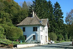 Border crossing | |
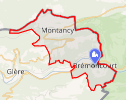 Location of Montancy | |
Montancy Montancy | |
| Coordinates: 47°20′50″N 7°02′52″E / 47.3472°N 7.0478°E / 47.3472; 7.0478 | |
| Country | France |
| Region | Bourgogne-Franche-Comté |
| Department | Doubs |
| Arrondissement | Montbéliard |
| Canton | Maîche |
| Government | |
| • Mayor (2023–2026) | Nicolas Jubin1 |
Area 1 | 8.86 km2 (3.42 sq mi) |
| Population (2023)2 | 127 |
| • Density | 14.3/km2 (37.1/sq mi) |
| Time zone | UTC+01:00 (CET) |
| • Summer (DST) | UTC+02:00 (CEST) |
| INSEE/Postal code | 25386 /25190 |
| Elevation | 410–920 m (1,350–3,020 ft) |
| 1 French Land Register data, which excludes lakes, ponds, glaciers > 1 km2 (0.386 sq mi or 247 acres) and river estuaries. | |
Montancy (French pronunciation: [mɔ̃tɑ̃si]; unofficial also Montancy-Brémoncourt) is a commune in the Doubs department in the Bourgogne-Franche-Comté region in eastern France.
Geography
The commune lies 23 km (14 mi) east of Saint-Hippolyte at the east end of the department near the Swiss border. The village of Brémoncourt lies in the valley of the Doubs at 430 m, and Montancy on the plateau at 900 m.
Population
| Year | Pop. | ±% |
|---|---|---|
| 1962 | 136 | — |
| 1968 | 146 | +7.4% |
| 1975 | 124 | −15.1% |
| 1982 | 122 | −1.6% |
| 1990 | 137 | +12.3% |
| 1999 | 152 | +10.9% |
| 2008 | 154 | +1.3% |
| 2012 | 158 | +2.6% |
References
References
- "Répertoire national des élus: les maires" (in French). data.gouv.fr, Plateforme ouverte des données publiques françaises. 30 November 2023.
- "Populations de référence 2023" (in French). National Institute of Statistics and Economic Studies. 18 December 2025.
External links
External links
External links
- Official Web site (in French)