Monreal | |
|---|---|
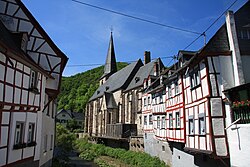 The Parish in Monreal, along the Eltzbach | |
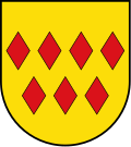 Coat of arms | |
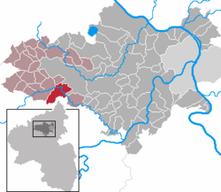
Location of Monreal
within Mayen-Koblenz district
| |
 Location of Monreal | |
Monreal Monreal | |
| Coordinates: 50°18′0″N 7°9′34″E / 50.30000°N 7.15944°E / 50.30000; 7.15944 | |
| Country | Germany |
| State | Rhineland-Palatinate |
| District | Mayen-Koblenz |
| Municipal assoc. | Vordereifel |
| Government | |
| • Mayor (2019–24) | André Übener1 |
| Area | |
• Total | 14.65 km2 (5.66 sq mi) |
| Elevation | 300 m (980 ft) |
| Population (2024-12-31)2 | |
• Total | 763 |
| • Density | 52.1/km2 (135/sq mi) |
| Time zone | UTC+01:00 (CET) |
| • Summer (DST) | UTC+02:00 (CEST) |
| Postal codes | 56729 |
| Dialling codes | 02651 |
| Vehicle registration | MYK |
| Website | www.monreal-eifel.de |
Monreal (German pronunciation: [mɔnʁeˈaːl]), Königsberg until the 13th century, is a municipality in the district of Mayen-Koblenz in Rhineland-Palatinate, Germany.
Above the village are the ruined castles of Löwenburg and Philippsburg.
Notable people
- Markus Meurer (born 1959), German outsider artist
Transport
Monreal train stop, which is located at Cross Eifel Railway, is served by line RB38 (Andernach - Mayen - Kaisersesch).
References
References
- Direktwahlen 2019, Landkreis Mayen-Koblenz, Landeswahlleiter Rheinland-Pfalz, accessed 5 August 2021.
- "Bevölkerungsstand von Land, Landkreisen, Gemeinden und Verbandsgemeinden 2024 (Einwohnerzahlen auf Grundlage des Zensus 2022)" (in German). Statistisches Landesamt Rheinland-Pfalz.