Moncy | |
|---|---|
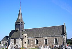 The church in Moncy | |
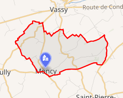 Location of Moncy | |
Moncy Moncy | |
| Coordinates: 48°49′32″N 0°41′06″W / 48.8256°N 0.685°W / 48.8256; -0.685 | |
| Country | France |
| Region | Normandy |
| Department | Orne |
| Arrondissement | Argentan |
| Canton | Flers-1 |
| Intercommunality | Domfront Tinchebray Interco |
| Government | |
| • Mayor (2020–2026) | Bruno Devère1 |
Area 1 | 7.75 km2 (2.99 sq mi) |
| Population (2023)2 | 261 |
| • Density | 33.7/km2 (87.2/sq mi) |
| Time zone | UTC+01:00 (CET) |
| • Summer (DST) | UTC+02:00 (CEST) |
| INSEE/Postal code | 61281 /61800 |
| Elevation | 133–212 m (436–696 ft) |
| 1 French Land Register data, which excludes lakes, ponds, glaciers > 1 km2 (0.386 sq mi or 247 acres) and river estuaries. | |
Moncy (French pronunciation: [mɔ̃si] ⓘ) is a commune in the Orne department in north-western France.
Geography
The commune is made up of the following collection of villages and hamlets, La Moissonnière, La Huberdière, Colmesnil, Le Bois de Moncy, La Halboudière, La Vionière, La Becanière and Moncy.3
The commune is on the border of the area known as Suisse Normande.43
References
References
- "Répertoire national des élus: les maires". data.gouv.fr, Plateforme ouverte des données publiques françaises (in French). 9 August 2021.
- "Populations de référence 2023" (in French). National Institute of Statistics and Economic Studies. 18 December 2025.
- "Google Maps". Google Maps.
- "Map of Suisse Normande" (PDF).