| Moldevatnet | |
|---|---|
 | |
| Location | Molde Municipality, Møre og Romsdal |
| Coordinates | 62°46′34″N 7°11′03″E / 62.77608°N 7.18411°E / 62.77608; 7.18411 |
| Type | Reservoir |
| Moldeelva | |
| Moldemarka | |
| Basin countries | Norway |
| Max. length | 835 metres (2,740 ft) |
| Max. width | 350 metres (1,150 ft) |
Surface area | 0.19 square kilometres (0.073 sq mi) |
Surface elevation | 343 metres (1,125 ft) |
| References | NVE1 |
| Location | |
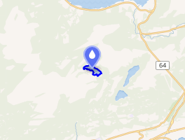 Interactive map of the lake | |
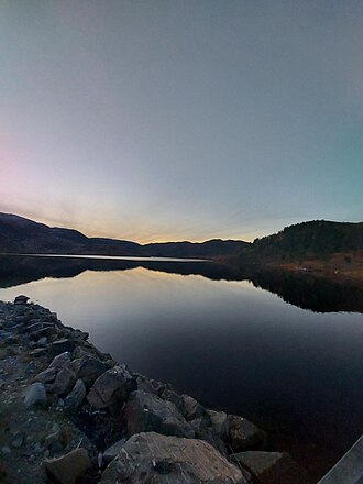
Moldevatnet2 (lit. 'Lake Molde') is the main reservoir and water supply for the city of Molde in Molde Municipality in Møre og Romsdal county, Norway.3 The 19-hectare (47-acre) lake is the source of the river Moldeelva and it is located about 4 kilometres (2.5 mi) north of the city, and the north end lies about 200 metres (660 ft) southeast of the border with Hustadvika Municipality.
References
References
- "Innsjødatabase". NVE.no (in Norwegian). Retrieved 23 March 2025.
- "Informasjon om stadnamn". Norgeskart (in Norwegian). Kartverket. Retrieved 23 March 2025.
- "Moldevatnet" (in Norwegian). yr.no. Retrieved 8 November 2010.