| Misty Range | |
|---|---|
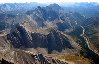 Misty Range with Mist Mountain and Mount Arethusa | |
| Highest point | |
| Peak | Mount Rae |
| Elevation | 3,218 m (10,558 ft)1 |
| Coordinates | 50°37′22″N 114°58′29″W / 50.62278°N 114.97472°W / 50.62278; -114.97472 (Mount Rae)2 |
| Dimensions | |
| Length | 18 km (11 mi) N-S3 |
| Width | 16 km (9.9 mi) E-W3 |
| Area | 136 km2 (53 mi2)3 |
| Geography | |
Misty Range Location in Alberta | |
Country | Canada |
Province | Alberta |
Range coordinates | 50°36′30″N 114°56′31″W / 50.60833°N 114.94194°W / 50.60833; -114.94194 (Misty Range)4 |
| Parent range | High Rock Range |
| Topo map | NTS 82J10 Mount Rae4 |
The Misty Range is a mountain range of the Canadian Rockies located east of the Bighorn Highway within Kananaskis Country, Canada.
It is a sub-range of the High Rock Range in the Southern Continental Ranges.3
List of Mountains
This range includes the following mountains:
| Name | Elevation | Prominence | Coordinates | ||
|---|---|---|---|---|---|
| m | ft | m | ft | ||
| Mount Rae | 3,218 | 10,558 | 1,330 | 4,360 | 50°37′22″N 114°58′29″W / 50.62278°N 114.97472°W / 50.62278; -114.97472 |
| Mist Mountain | 3,140 | 10,300 | 487 | 1,598 | 50°33′15″N 114°54′36″W / 50.55417°N 114.91000°W / 50.55417; -114.91000 |
| Storm Mountain | 3,095 | 10,154 | 291 | 955 | 50°35′13″N 114°56′23″W / 50.58694°N 114.93972°W / 50.58694; -114.93972 |
| Mount Arethusa | 2,912 | 9,554 | 138 | 453 | 50°36′27″N 114°58′4″W / 50.60750°N 114.96778°W / 50.60750; -114.96778 |
References
References
- "Mount Rae". cdnrockiesdatabases.ca. Retrieved 2012-05-13.
- "Mount Rae". Geographical Names Data Base. Natural Resources Canada. Retrieved 2023-09-08.
- "Misty Range". Peakbagger.com. Retrieved 2006-10-07.
- "Misty Range". Geographical Names Data Base. Natural Resources Canada. Retrieved 2019-07-09.